You are here: Home > Network List > AV - Alaska Volcano Observatory Stations List
> Station SPCR Ckakachatna River, Mount Spurr, Alaska > Earthquake Result Viewer
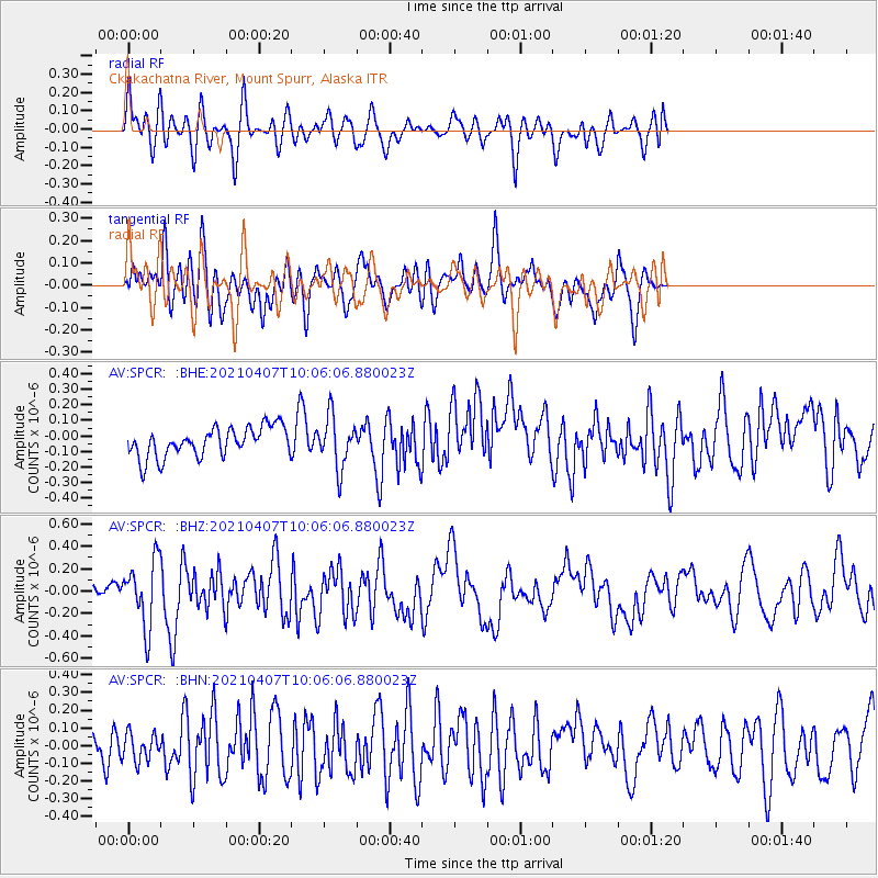
SPCR Ckakachatna River, Mount Spurr, Alaska - Earthquake Result Viewer
*The percent match for this event was below the threshold and hence no stack was calculated.
| Earthquake location: |
Kermadec Islands Region |
| Earthquake latitude/longitude: |
-29.1/-176.7 |
| Earthquake time(UTC): |
2021/04/07 (097) 09:53:28 GMT |
| Earthquake Depth: |
10 km |
| Earthquake Magnitude: |
6.0 Mww |
| Earthquake Catalog/Contributor: |
NEIC PDE/us |
|
| Network: |
AV Alaska Volcano Observatory |
| Station: |
SPCR Ckakachatna River, Mount Spurr, Alaska |
| Lat/Lon: |
61.20 N/152.21 W |
| Elevation: |
984 m |
|
| Distance: |
92.2 deg |
| Az: |
11.576 deg |
| Baz: |
201.264 deg |
| Ray Param: |
$rayparam |
*The percent match for this event was below the threshold and hence was not used in the summary stack. |
|
| Radial Match: |
60.342663 % |
| Radial Bump: |
400 |
| Transverse Match: |
50.739155 % |
| Transverse Bump: |
400 |
| SOD ConfigId: |
24334971 |
| Insert Time: |
2021-04-21 09:58:38.332 +0000 |
| GWidth: |
2.5 |
| Max Bumps: |
400 |
| Tol: |
0.001 |
|
Signal To Noise
| Channel | StoN | STA | LTA |
| AV:SPCR: :BHZ:20210407T10:06:06.880023Z | 3.5797253 | 2.9066376E-7 | 8.119723E-8 |
| AV:SPCR: :BHN:20210407T10:06:06.880023Z | 0.744099 | 7.7295496E-8 | 1.03877966E-7 |
| AV:SPCR: :BHE:20210407T10:06:06.880023Z | 1.730297 | 1.6423927E-7 | 9.4919706E-8 |
| Arrivals |
| Ps | |
| PpPs | |
| PsPs/PpSs | |


