You are here: Home > Network List > CI - Caltech Regional Seismic Network Stations List
> Station MUR Murrieta > Earthquake Result Viewer
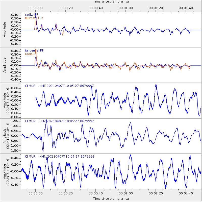
MUR Murrieta - Earthquake Result Viewer
*The percent match for this event was below the threshold and hence no stack was calculated.
| Earthquake location: |
Kermadec Islands Region |
| Earthquake latitude/longitude: |
-29.1/-176.7 |
| Earthquake time(UTC): |
2021/04/07 (097) 09:53:28 GMT |
| Earthquake Depth: |
10 km |
| Earthquake Magnitude: |
6.0 Mww |
| Earthquake Catalog/Contributor: |
NEIC PDE/us |
|
| Network: |
CI Caltech Regional Seismic Network |
| Station: |
MUR Murrieta |
| Lat/Lon: |
33.60 N/117.20 W |
| Elevation: |
562 m |
|
| Distance: |
84.0 deg |
| Az: |
46.297 deg |
| Baz: |
229.29 deg |
| Ray Param: |
$rayparam |
*The percent match for this event was below the threshold and hence was not used in the summary stack. |
|
| Radial Match: |
70.68832 % |
| Radial Bump: |
346 |
| Transverse Match: |
66.48739 % |
| Transverse Bump: |
400 |
| SOD ConfigId: |
24334971 |
| Insert Time: |
2021-04-21 10:02:40.534 +0000 |
| GWidth: |
2.5 |
| Max Bumps: |
400 |
| Tol: |
0.001 |
|
Signal To Noise
| Channel | StoN | STA | LTA |
| CI:MUR: :HHZ:20210407T10:05:27.867999Z | 3.7862344 | 4.550409E-7 | 1.2018296E-7 |
| CI:MUR: :HHN:20210407T10:05:27.867999Z | 1.2796974 | 1.6011991E-7 | 1.2512326E-7 |
| CI:MUR: :HHE:20210407T10:05:27.867999Z | 1.3174777 | 2.1661154E-7 | 1.644138E-7 |
| Arrivals |
| Ps | |
| PpPs | |
| PsPs/PpSs | |


