You are here: Home > Network List > IW - Intermountain West Stations List
> Station DLMT Dillon, Montana, USA > Earthquake Result Viewer
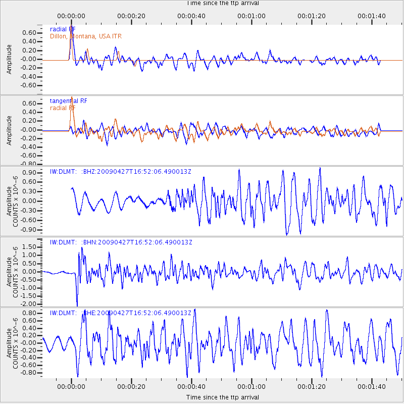
DLMT Dillon, Montana, USA - Earthquake Result Viewer
*The percent match for this event was below the threshold and hence no stack was calculated.
| Earthquake location: |
Guerrero, Mexico |
| Earthquake latitude/longitude: |
17.0/-99.4 |
| Earthquake time(UTC): |
2009/04/27 (117) 16:46:28 GMT |
| Earthquake Depth: |
35 km |
| Earthquake Magnitude: |
5.7 MB, 5.4 MS, 5.8 MW, 5.8 MW |
| Earthquake Catalog/Contributor: |
WHDF/NEIC |
|
| Network: |
IW Intermountain West |
| Station: |
DLMT Dillon, Montana, USA |
| Lat/Lon: |
45.36 N/112.60 W |
| Elevation: |
1569 m |
|
| Distance: |
30.3 deg |
| Az: |
341.474 deg |
| Baz: |
154.458 deg |
| Ray Param: |
$rayparam |
*The percent match for this event was below the threshold and hence was not used in the summary stack. |
|
| Radial Match: |
77.59753 % |
| Radial Bump: |
400 |
| Transverse Match: |
62.908592 % |
| Transverse Bump: |
400 |
| SOD ConfigId: |
2658 |
| Insert Time: |
2010-03-09 07:13:13.626 +0000 |
| GWidth: |
2.5 |
| Max Bumps: |
400 |
| Tol: |
0.001 |
|
Signal To Noise
| Channel | StoN | STA | LTA |
| IW:DLMT: :BHN:20090427T16:52:06.490013Z | 15.591734 | 7.9955754E-7 | 5.128086E-8 |
| IW:DLMT: :BHE:20090427T16:52:06.490013Z | 3.585918 | 4.8152526E-7 | 1.3428227E-7 |
| IW:DLMT: :BHZ:20090427T16:52:06.490013Z | 0.80981034 | 1.5907459E-7 | 1.9643439E-7 |
| Arrivals |
| Ps | |
| PpPs | |
| PsPs/PpSs | |


