You are here: Home > Network List > NN - Western Great Basin/Eastern Sierra Nevada Stations List
> Station ZPR Zephyr Cove, Lake Tahoe, Nevada > Earthquake Result Viewer
ZPR Zephyr Cove, Lake Tahoe, Nevada - Earthquake Result Viewer
| Earthquake location: |
Kermadec Islands Region |
| Earthquake latitude/longitude: |
-29.1/-176.7 |
| Earthquake time(UTC): |
2021/04/07 (097) 09:53:28 GMT |
| Earthquake Depth: |
10 km |
| Earthquake Magnitude: |
6.0 Mww |
| Earthquake Catalog/Contributor: |
NEIC PDE/us |
|
| Network: |
NN Western Great Basin/Eastern Sierra Nevada |
| Station: |
ZPR Zephyr Cove, Lake Tahoe, Nevada |
| Lat/Lon: |
39.01 N/119.94 W |
| Elevation: |
2001 m |
|
| Distance: |
86.0 deg |
| Az: |
40.771 deg |
| Baz: |
227.187 deg |
| Ray Param: |
0.0444037 |
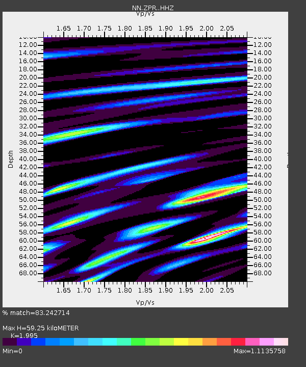
| Estimated Moho Depth: |
59.25 km |
| Estimated Crust Vp/Vs: |
2.00 |
| Assumed Crust Vp: |
6.279 km/s |
| Estimated Crust Vs: |
3.147 km/s |
| Estimated Crust Poisson's Ratio: |
0.33 |
|
| Radial Match: |
83.242714 % |
| Radial Bump: |
400 |
| Transverse Match: |
97.13456 % |
| Transverse Bump: |
118 |
| SOD ConfigId: |
24334971 |
| Insert Time: |
2021-04-21 10:07:14.388 +0000 |
| GWidth: |
2.5 |
| Max Bumps: |
400 |
| Tol: |
0.001 |
|

Signal To Noise
| Channel | StoN | STA | LTA |
| NN:ZPR: :HHZ:20210407T10:05:37.607989Z | 1.4641315 | 1.7458682E-7 | 1.1924259E-7 |
| NN:ZPR: :HHN:20210407T10:05:37.607989Z | 1.3068138 | 2.0927115E-7 | 1.6013846E-7 |
| NN:ZPR: :HHE:20210407T10:05:37.607989Z | 1.1174526 | 1.4149151E-7 | 1.266197E-7 |
| Arrivals |
| Ps | 9.6 SECOND |
| PpPs | 28 SECOND |
| PsPs/PpSs | 37 SECOND |


