You are here: Home > Network List > TA - USArray Transportable Network (new EarthScope stations) Stations List
> Station O17K Koliganek, Bristol Bay, AK, USA > Earthquake Result Viewer
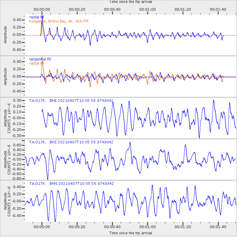
O17K Koliganek, Bristol Bay, AK, USA - Earthquake Result Viewer
*The percent match for this event was below the threshold and hence no stack was calculated.
| Earthquake location: |
Kermadec Islands Region |
| Earthquake latitude/longitude: |
-29.1/-176.7 |
| Earthquake time(UTC): |
2021/04/07 (097) 09:53:28 GMT |
| Earthquake Depth: |
10 km |
| Earthquake Magnitude: |
6.0 Mww |
| Earthquake Catalog/Contributor: |
NEIC PDE/us |
|
| Network: |
TA USArray Transportable Network (new EarthScope stations) |
| Station: |
O17K Koliganek, Bristol Bay, AK, USA |
| Lat/Lon: |
59.77 N/157.09 W |
| Elevation: |
156 m |
|
| Distance: |
90.0 deg |
| Az: |
9.761 deg |
| Baz: |
197.053 deg |
| Ray Param: |
$rayparam |
*The percent match for this event was below the threshold and hence was not used in the summary stack. |
|
| Radial Match: |
75.04157 % |
| Radial Bump: |
368 |
| Transverse Match: |
63.45132 % |
| Transverse Bump: |
385 |
| SOD ConfigId: |
24334971 |
| Insert Time: |
2021-04-21 10:10:11.911 +0000 |
| GWidth: |
2.5 |
| Max Bumps: |
400 |
| Tol: |
0.001 |
|
Signal To Noise
| Channel | StoN | STA | LTA |
| TA:O17K: :BHZ:20210407T10:05:56.974994Z | 3.2977643 | 3.5557136E-7 | 1.0782195E-7 |
| TA:O17K: :BHN:20210407T10:05:56.974994Z | 3.4335845 | 2.2303362E-7 | 6.4956495E-8 |
| TA:O17K: :BHE:20210407T10:05:56.974994Z | 0.9774662 | 1.0869291E-7 | 1.1119863E-7 |
| Arrivals |
| Ps | |
| PpPs | |
| PsPs/PpSs | |


