You are here: Home > Network List > US - United States National Seismic Network Stations List
> Station EGMT Eagleton, Montana, USA > Earthquake Result Viewer
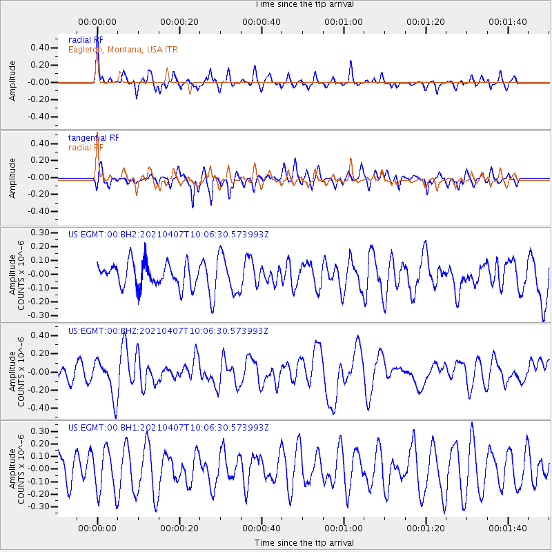
EGMT Eagleton, Montana, USA - Earthquake Result Viewer
*The percent match for this event was below the threshold and hence no stack was calculated.
| Earthquake location: |
Kermadec Islands Region |
| Earthquake latitude/longitude: |
-29.1/-176.7 |
| Earthquake time(UTC): |
2021/04/07 (097) 09:53:28 GMT |
| Earthquake Depth: |
10 km |
| Earthquake Magnitude: |
6.0 Mww |
| Earthquake Catalog/Contributor: |
NEIC PDE/us |
|
| Network: |
US United States National Seismic Network |
| Station: |
EGMT Eagleton, Montana, USA |
| Lat/Lon: |
48.02 N/109.75 W |
| Elevation: |
1055 m |
|
| Distance: |
97.4 deg |
| Az: |
38.514 deg |
| Baz: |
234.272 deg |
| Ray Param: |
$rayparam |
*The percent match for this event was below the threshold and hence was not used in the summary stack. |
|
| Radial Match: |
63.67643 % |
| Radial Bump: |
316 |
| Transverse Match: |
47.281296 % |
| Transverse Bump: |
400 |
| SOD ConfigId: |
24334971 |
| Insert Time: |
2021-04-21 10:12:34.965 +0000 |
| GWidth: |
2.5 |
| Max Bumps: |
400 |
| Tol: |
0.001 |
|
Signal To Noise
| Channel | StoN | STA | LTA |
| US:EGMT:00:BHZ:20210407T10:06:30.573993Z | 2.9256523 | 2.1421857E-7 | 7.322079E-8 |
| US:EGMT:00:BH1:20210407T10:06:30.573993Z | 1.6207706 | 1.7502379E-7 | 1.0798801E-7 |
| US:EGMT:00:BH2:20210407T10:06:30.573993Z | 1.5567133 | 1.3075744E-7 | 8.3995836E-8 |
| Arrivals |
| Ps | |
| PpPs | |
| PsPs/PpSs | |


