You are here: Home > Network List > IW - Intermountain West Stations List
> Station DLMT Dillon, Montana, USA > Earthquake Result Viewer
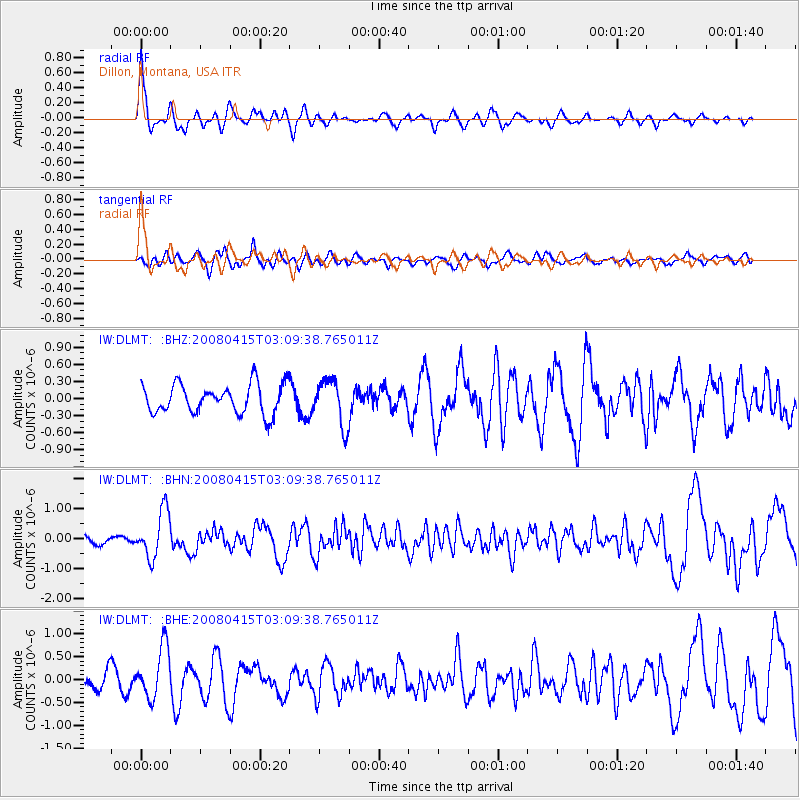
DLMT Dillon, Montana, USA - Earthquake Result Viewer
*The percent match for this event was below the threshold and hence no stack was calculated.
| Earthquake location: |
Near Coast Of Guatemala |
| Earthquake latitude/longitude: |
13.6/-90.6 |
| Earthquake time(UTC): |
2008/04/15 (106) 03:03:04 GMT |
| Earthquake Depth: |
33 km |
| Earthquake Magnitude: |
5.6 MB, 5.8 MS, 6.1 MW, 6.1 MW |
| Earthquake Catalog/Contributor: |
WHDF/NEIC |
|
| Network: |
IW Intermountain West |
| Station: |
DLMT Dillon, Montana, USA |
| Lat/Lon: |
45.36 N/112.60 W |
| Elevation: |
1569 m |
|
| Distance: |
36.8 deg |
| Az: |
333.829 deg |
| Baz: |
142.527 deg |
| Ray Param: |
$rayparam |
*The percent match for this event was below the threshold and hence was not used in the summary stack. |
|
| Radial Match: |
79.468636 % |
| Radial Bump: |
400 |
| Transverse Match: |
59.291862 % |
| Transverse Bump: |
400 |
| SOD ConfigId: |
2504 |
| Insert Time: |
2010-03-09 07:13:51.205 +0000 |
| GWidth: |
2.5 |
| Max Bumps: |
400 |
| Tol: |
0.001 |
|
Signal To Noise
| Channel | StoN | STA | LTA |
| IW:DLMT: :BHN:20080415T03:09:38.765011Z | 5.6672955 | 7.85279E-7 | 1.3856327E-7 |
| IW:DLMT: :BHE:20080415T03:09:38.765011Z | 3.6196873 | 5.601974E-7 | 1.5476402E-7 |
| IW:DLMT: :BHZ:20080415T03:09:38.765011Z | 1.5761695 | 3.9744643E-7 | 2.521597E-7 |
| Arrivals |
| Ps | |
| PpPs | |
| PsPs/PpSs | |


