You are here: Home > Network List > UU - University of Utah Regional Network Stations List
> Station SZCU Shurtz Canyon, UT, USA > Earthquake Result Viewer
SZCU Shurtz Canyon, UT, USA - Earthquake Result Viewer
| Earthquake location: |
Kermadec Islands Region |
| Earthquake latitude/longitude: |
-29.1/-176.7 |
| Earthquake time(UTC): |
2021/04/07 (097) 09:53:28 GMT |
| Earthquake Depth: |
10 km |
| Earthquake Magnitude: |
6.0 Mww |
| Earthquake Catalog/Contributor: |
NEIC PDE/us |
|
| Network: |
UU University of Utah Regional Network |
| Station: |
SZCU Shurtz Canyon, UT, USA |
| Lat/Lon: |
37.60 N/113.09 W |
| Elevation: |
2026 m |
|
| Distance: |
89.1 deg |
| Az: |
45.354 deg |
| Baz: |
231.616 deg |
| Ray Param: |
0.042085852 |
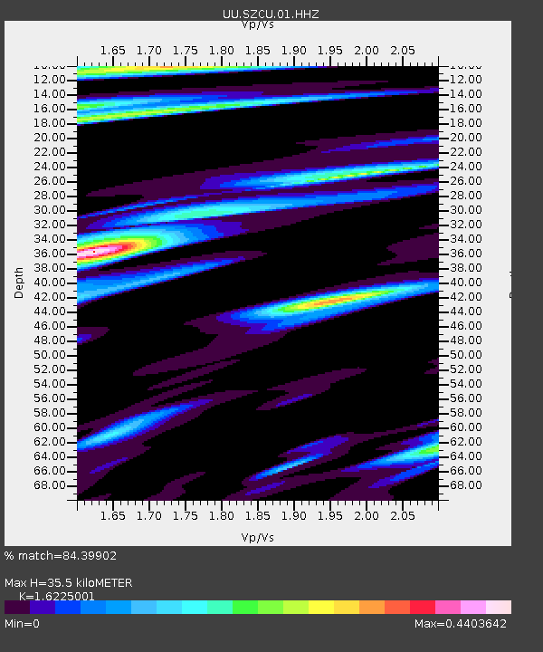
| Estimated Moho Depth: |
35.5 km |
| Estimated Crust Vp/Vs: |
1.62 |
| Assumed Crust Vp: |
6.194 km/s |
| Estimated Crust Vs: |
3.818 km/s |
| Estimated Crust Poisson's Ratio: |
0.19 |
|
| Radial Match: |
84.39902 % |
| Radial Bump: |
302 |
| Transverse Match: |
63.533752 % |
| Transverse Bump: |
400 |
| SOD ConfigId: |
24334971 |
| Insert Time: |
2021-04-21 10:13:25.262 +0000 |
| GWidth: |
2.5 |
| Max Bumps: |
400 |
| Tol: |
0.001 |
|

Signal To Noise
| Channel | StoN | STA | LTA |
| UU:SZCU:01:HHZ:20210407T10:05:52.839984Z | 2.157429 | 6.8656294E-9 | 3.1823202E-9 |
| UU:SZCU:01:HHN:20210407T10:05:52.839984Z | 0.40674713 | 1.0512737E-9 | 2.5845879E-9 |
| UU:SZCU:01:HHE:20210407T10:05:52.839984Z | 2.2265396 | 4.0992103E-9 | 1.8410677E-9 |
| Arrivals |
| Ps | 3.6 SECOND |
| PpPs | 15 SECOND |
| PsPs/PpSs | 18 SECOND |


