You are here: Home > Network List > US - United States National Seismic Network Stations List
> Station HAWA Hanford, Washington, USA > Earthquake Result Viewer
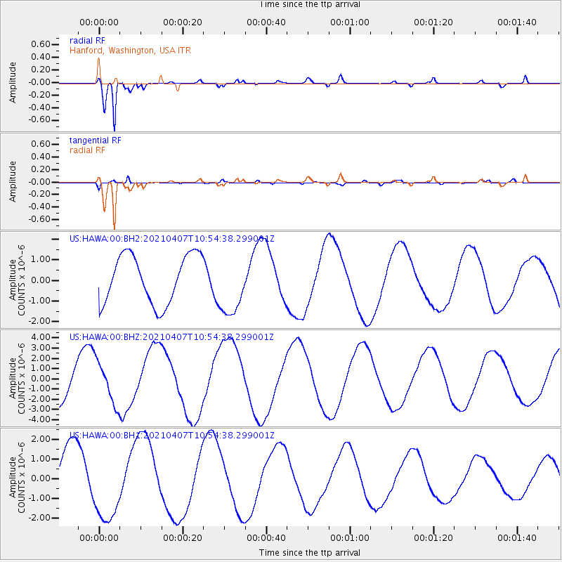
HAWA Hanford, Washington, USA - Earthquake Result Viewer
*The percent match for this event was below the threshold and hence no stack was calculated.
| Earthquake location: |
Kermadec Islands Region |
| Earthquake latitude/longitude: |
-28.8/-176.8 |
| Earthquake time(UTC): |
2021/04/07 (097) 10:42:05 GMT |
| Earthquake Depth: |
10 km |
| Earthquake Magnitude: |
5.4 Mww |
| Earthquake Catalog/Contributor: |
NEIC PDE/us |
|
| Network: |
US United States National Seismic Network |
| Station: |
HAWA Hanford, Washington, USA |
| Lat/Lon: |
46.39 N/119.53 W |
| Elevation: |
364 m |
|
| Distance: |
91.0 deg |
| Az: |
35.598 deg |
| Baz: |
227.579 deg |
| Ray Param: |
$rayparam |
*The percent match for this event was below the threshold and hence was not used in the summary stack. |
|
| Radial Match: |
95.47757 % |
| Radial Bump: |
400 |
| Transverse Match: |
71.831474 % |
| Transverse Bump: |
400 |
| SOD ConfigId: |
24334971 |
| Insert Time: |
2021-04-21 10:55:08.770 +0000 |
| GWidth: |
2.5 |
| Max Bumps: |
400 |
| Tol: |
0.001 |
|
Signal To Noise
| Channel | StoN | STA | LTA |
| US:HAWA:00:BHZ:20210407T10:54:38.299001Z | 1.1371423 | 1.9812207E-6 | 1.7422806E-6 |
| US:HAWA:00:BH1:20210407T10:54:38.299001Z | 1.55586 | 1.9581091E-6 | 1.2585381E-6 |
| US:HAWA:00:BH2:20210407T10:54:38.299001Z | 1.2697866 | 1.4905886E-6 | 1.173889E-6 |
| Arrivals |
| Ps | |
| PpPs | |
| PsPs/PpSs | |


