You are here: Home > Network List > IW - Intermountain West Stations List
> Station FLWY Flagg Ranch, Wyoming, USA > Earthquake Result Viewer
FLWY Flagg Ranch, Wyoming, USA - Earthquake Result Viewer
| Earthquake location: |
Tonga Islands |
| Earthquake latitude/longitude: |
-16.3/-173.5 |
| Earthquake time(UTC): |
2009/10/02 (275) 01:07:39 GMT |
| Earthquake Depth: |
8.0 km |
| Earthquake Magnitude: |
6.1 MB, 6.0 MS, 6.1 MW, 6.1 MW |
| Earthquake Catalog/Contributor: |
WHDF/NEIC |
|
| Network: |
IW Intermountain West |
| Station: |
FLWY Flagg Ranch, Wyoming, USA |
| Lat/Lon: |
44.08 N/110.70 W |
| Elevation: |
2078 m |
|
| Distance: |
82.9 deg |
| Az: |
40.218 deg |
| Baz: |
239.346 deg |
| Ray Param: |
0.04653784 |
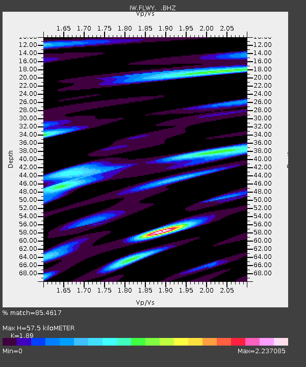
| Estimated Moho Depth: |
57.5 km |
| Estimated Crust Vp/Vs: |
1.89 |
| Assumed Crust Vp: |
6.35 km/s |
| Estimated Crust Vs: |
3.36 km/s |
| Estimated Crust Poisson's Ratio: |
0.31 |
|
| Radial Match: |
85.4617 % |
| Radial Bump: |
400 |
| Transverse Match: |
83.71763 % |
| Transverse Bump: |
400 |
| SOD ConfigId: |
2622 |
| Insert Time: |
2010-03-09 07:14:31.294 +0000 |
| GWidth: |
2.5 |
| Max Bumps: |
400 |
| Tol: |
0.001 |
|

Signal To Noise
| Channel | StoN | STA | LTA |
| IW:FLWY: :BHZ:20091002T01:19:33.14501Z | 7.4466105 | 5.3496296E-7 | 7.183979E-8 |
| IW:FLWY: :BHN:20091002T01:19:33.14501Z | 1.2673823 | 2.1874362E-7 | 1.7259484E-7 |
| IW:FLWY: :BHE:20091002T01:19:33.14501Z | 1.821539 | 1.925031E-7 | 1.05681565E-7 |
| Arrivals |
| Ps | 8.3 SECOND |
| PpPs | 26 SECOND |
| PsPs/PpSs | 34 SECOND |


