You are here: Home > Network List > IW - Intermountain West Stations List
> Station FXWY Fox Creek, Wyoming, USA > Earthquake Result Viewer
FXWY Fox Creek, Wyoming, USA - Earthquake Result Viewer
| Earthquake location: |
Tonga Islands |
| Earthquake latitude/longitude: |
-16.3/-173.5 |
| Earthquake time(UTC): |
2009/10/02 (275) 01:07:39 GMT |
| Earthquake Depth: |
8.0 km |
| Earthquake Magnitude: |
6.1 MB, 6.0 MS, 6.1 MW, 6.1 MW |
| Earthquake Catalog/Contributor: |
WHDF/NEIC |
|
| Network: |
IW Intermountain West |
| Station: |
FXWY Fox Creek, Wyoming, USA |
| Lat/Lon: |
43.64 N/111.03 W |
| Elevation: |
2254 m |
|
| Distance: |
82.5 deg |
| Az: |
40.481 deg |
| Baz: |
239.153 deg |
| Ray Param: |
0.04683733 |
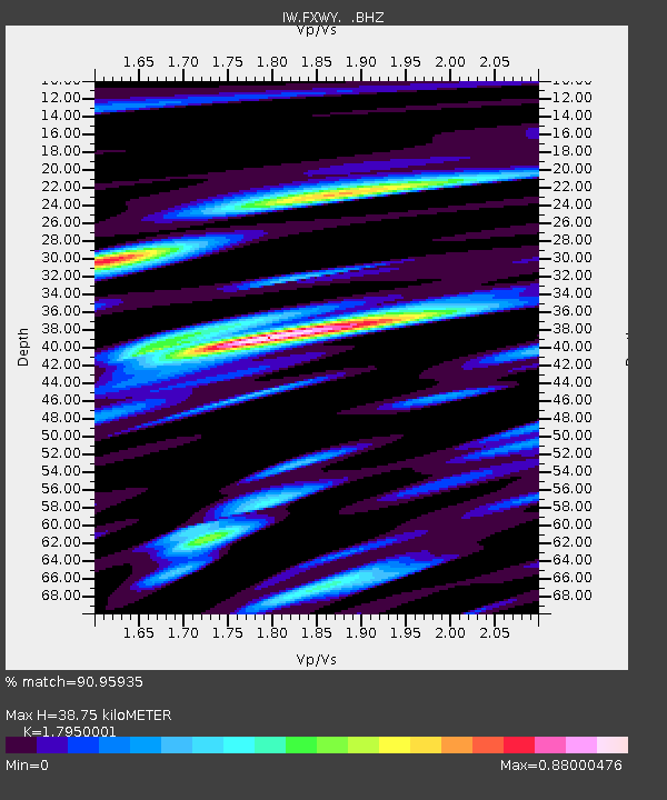
| Estimated Moho Depth: |
38.75 km |
| Estimated Crust Vp/Vs: |
1.80 |
| Assumed Crust Vp: |
6.207 km/s |
| Estimated Crust Vs: |
3.458 km/s |
| Estimated Crust Poisson's Ratio: |
0.27 |
|
| Radial Match: |
90.95935 % |
| Radial Bump: |
400 |
| Transverse Match: |
81.16082 % |
| Transverse Bump: |
400 |
| SOD ConfigId: |
2622 |
| Insert Time: |
2010-03-09 07:16:00.406 +0000 |
| GWidth: |
2.5 |
| Max Bumps: |
400 |
| Tol: |
0.001 |
|
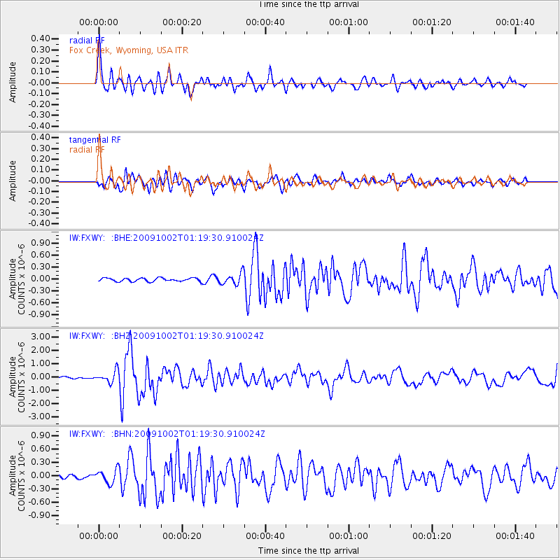
Signal To Noise
| Channel | StoN | STA | LTA |
| IW:FXWY: :BHZ:20091002T01:19:30.910024Z | 3.6933079 | 4.4288274E-7 | 1.1991493E-7 |
| IW:FXWY: :BHN:20091002T01:19:30.910024Z | 2.46605 | 1.5980314E-7 | 6.4801256E-8 |
| IW:FXWY: :BHE:20091002T01:19:30.910024Z | 3.5239966 | 1.4680556E-7 | 4.1658826E-8 |
| Arrivals |
| Ps | 5.1 SECOND |
| PpPs | 17 SECOND |
| PsPs/PpSs | 22 SECOND |


