You are here: Home > Network List > TX - Texas Seismological Network Stations List
> Station MB02 Rankin > Earthquake Result Viewer
MB02 Rankin - Earthquake Result Viewer
| Earthquake location: |
Central Alaska |
| Earthquake latitude/longitude: |
63.2/-148.7 |
| Earthquake time(UTC): |
2021/04/08 (098) 17:10:15 GMT |
| Earthquake Depth: |
0.7 km |
| Earthquake Magnitude: |
5.9 ml |
| Earthquake Catalog/Contributor: |
NEIC PDE/ak |
|
| Network: |
TX Texas Seismological Network |
| Station: |
MB02 Rankin |
| Lat/Lon: |
31.20 N/102.04 W |
| Elevation: |
768 m |
|
| Distance: |
43.4 deg |
| Az: |
115.003 deg |
| Baz: |
331.337 deg |
| Ray Param: |
0.072584584 |
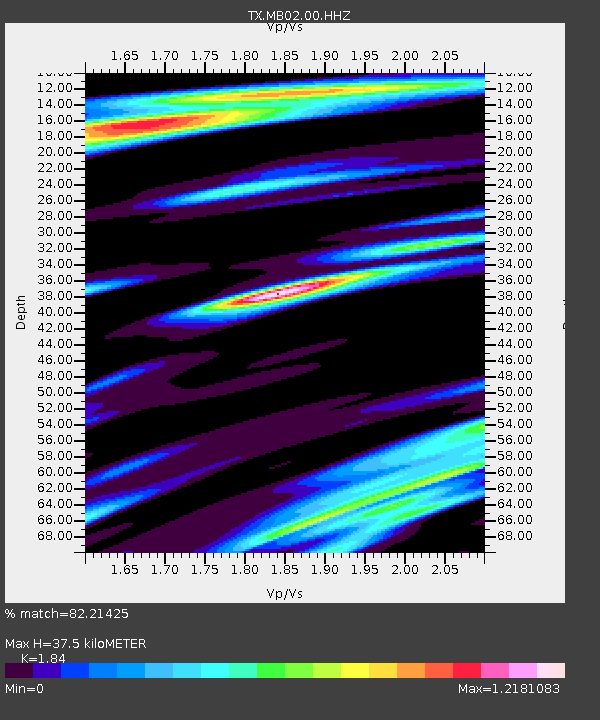
| Estimated Moho Depth: |
37.5 km |
| Estimated Crust Vp/Vs: |
1.84 |
| Assumed Crust Vp: |
6.121 km/s |
| Estimated Crust Vs: |
3.326 km/s |
| Estimated Crust Poisson's Ratio: |
0.29 |
|
| Radial Match: |
82.21425 % |
| Radial Bump: |
400 |
| Transverse Match: |
68.80737 % |
| Transverse Bump: |
400 |
| SOD ConfigId: |
24334971 |
| Insert Time: |
2021-04-22 17:29:10.203 +0000 |
| GWidth: |
2.5 |
| Max Bumps: |
400 |
| Tol: |
0.001 |
|

Signal To Noise
| Channel | StoN | STA | LTA |
| TX:MB02:00:HHZ:20210408T17:17:49.169996Z | 2.4917424 | 9.509093E-8 | 3.8162426E-8 |
| TX:MB02:00:HH1:20210408T17:17:49.169996Z | 2.6265252 | 9.199871E-8 | 3.5026776E-8 |
| TX:MB02:00:HH2:20210408T17:17:49.169996Z | 3.92216 | 9.549944E-8 | 2.4348687E-8 |
| Arrivals |
| Ps | 5.5 SECOND |
| PpPs | 16 SECOND |
| PsPs/PpSs | 22 SECOND |


