You are here: Home > Network List > IW - Intermountain West Stations List
> Station IMW Indian Meadow, Wyoming, USA > Earthquake Result Viewer
IMW Indian Meadow, Wyoming, USA - Earthquake Result Viewer
| Earthquake location: |
Andreanof Islands, Aleutian Is. |
| Earthquake latitude/longitude: |
51.4/-179.5 |
| Earthquake time(UTC): |
2007/12/19 (353) 09:30:27 GMT |
| Earthquake Depth: |
29 km |
| Earthquake Magnitude: |
6.4 MB, 7.1 MS, 7.1 MW, 7.0 MW |
| Earthquake Catalog/Contributor: |
WHDF/NEIC |
|
| Network: |
IW Intermountain West |
| Station: |
IMW Indian Meadow, Wyoming, USA |
| Lat/Lon: |
43.90 N/110.94 W |
| Elevation: |
2646 m |
|
| Distance: |
45.3 deg |
| Az: |
71.32 deg |
| Baz: |
304.758 deg |
| Ray Param: |
0.071333505 |
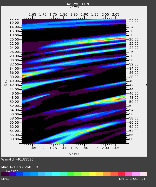
| Estimated Moho Depth: |
48.0 km |
| Estimated Crust Vp/Vs: |
2.10 |
| Assumed Crust Vp: |
6.207 km/s |
| Estimated Crust Vs: |
2.963 km/s |
| Estimated Crust Poisson's Ratio: |
0.35 |
|
| Radial Match: |
91.83536 % |
| Radial Bump: |
400 |
| Transverse Match: |
77.53763 % |
| Transverse Bump: |
400 |
| SOD ConfigId: |
2564 |
| Insert Time: |
2010-03-09 07:16:31.480 +0000 |
| GWidth: |
2.5 |
| Max Bumps: |
400 |
| Tol: |
0.001 |
|
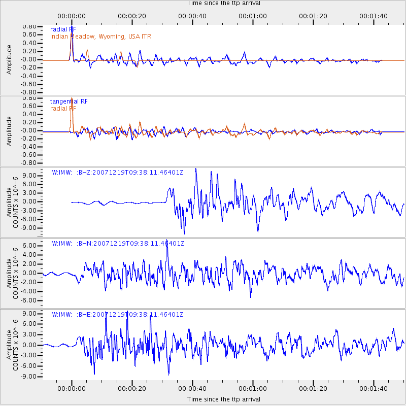
Signal To Noise
| Channel | StoN | STA | LTA |
| IW:IMW: :BHN:20071219T09:38:11.46401Z | 4.607177 | 1.127029E-6 | 2.4462466E-7 |
| IW:IMW: :BHE:20071219T09:38:11.46401Z | 7.47514 | 1.4879175E-6 | 1.9904878E-7 |
| IW:IMW: :BHZ:20071219T09:38:11.46401Z | 8.551957 | 2.6604062E-6 | 3.110874E-7 |
| Arrivals |
| Ps | 8.9 SECOND |
| PpPs | 23 SECOND |
| PsPs/PpSs | 32 SECOND |


