You are here: Home > Network List > IW - Intermountain West Stations List
> Station IMW Indian Meadow, Wyoming, USA > Earthquake Result Viewer
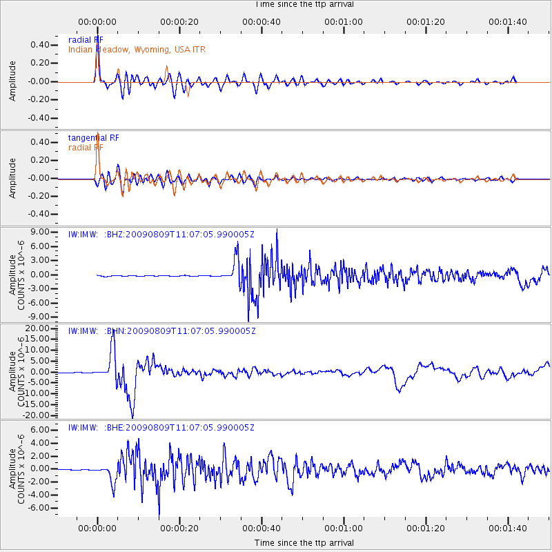
IMW Indian Meadow, Wyoming, USA - Earthquake Result Viewer

| Earthquake location: |
Near S. Coast Of Honshu, Japan |
| Earthquake latitude/longitude: |
33.2/137.9 |
| Earthquake time(UTC): |
2009/08/09 (221) 10:55:55 GMT |
| Earthquake Depth: |
297 km |
| Earthquake Magnitude: |
6.5 MB, 7.1 MW, 7.1 MW |
| Earthquake Catalog/Contributor: |
WHDF/NEIC |
|
| Network: |
IW Intermountain West |
| Station: |
IMW Indian Meadow, Wyoming, USA |
| Lat/Lon: |
43.90 N/110.94 W |
| Elevation: |
2646 m |
|
| Distance: |
80.9 deg |
| Az: |
43.071 deg |
| Baz: |
307.596 deg |
| Ray Param: |
0.047159478 |
| Estimated Moho Depth: |
41.75 km |
| Estimated Crust Vp/Vs: |
2.04 |
| Assumed Crust Vp: |
6.207 km/s |
| Estimated Crust Vs: |
3.05 km/s |
| Estimated Crust Poisson's Ratio: |
0.34 |
|
| Radial Match: |
94.79963 % |
| Radial Bump: |
400 |
| Transverse Match: |
85.478676 % |
| Transverse Bump: |
400 |
| SOD ConfigId: |
2622 |
| Insert Time: |
2010-03-09 07:16:38.004 +0000 |
| GWidth: |
2.5 |
| Max Bumps: |
400 |
| Tol: |
0.001 |
|
Signal To Noise
| Channel | StoN | STA | LTA |
| IW:IMW: :BHN:20090809T11:07:05.990005Z | 150.04681 | 7.4525797E-6 | 4.9668365E-8 |
| IW:IMW: :BHE:20090809T11:07:05.990005Z | 68.24149 | 1.4094114E-6 | 2.065329E-8 |
| IW:IMW: :BHZ:20090809T11:07:05.990005Z | 33.591644 | 2.5486966E-6 | 7.587293E-8 |
| Arrivals |
| Ps | 7.1 SECOND |
| PpPs | 20 SECOND |
| PsPs/PpSs | 27 SECOND |


