You are here: Home > Network List > GO - National Seismic Network of Georgia Stations List
> Station TBLG Delisi, Georgia > Earthquake Result Viewer
TBLG Delisi, Georgia - Earthquake Result Viewer
| Earthquake location: |
Java, Indonesia |
| Earthquake latitude/longitude: |
-8.6/112.5 |
| Earthquake time(UTC): |
2021/04/10 (100) 07:00:17 GMT |
| Earthquake Depth: |
82 km |
| Earthquake Magnitude: |
6.0 Mww |
| Earthquake Catalog/Contributor: |
NEIC PDE/us |
|
| Network: |
GO National Seismic Network of Georgia |
| Station: |
TBLG Delisi, Georgia |
| Lat/Lon: |
41.73 N/44.74 E |
| Elevation: |
510 m |
|
| Distance: |
79.5 deg |
| Az: |
315.198 deg |
| Baz: |
111.395 deg |
| Ray Param: |
0.048726812 |
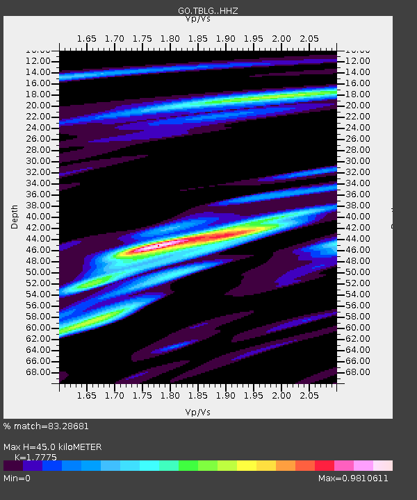
| Estimated Moho Depth: |
45.0 km |
| Estimated Crust Vp/Vs: |
1.78 |
| Assumed Crust Vp: |
6.291 km/s |
| Estimated Crust Vs: |
3.539 km/s |
| Estimated Crust Poisson's Ratio: |
0.27 |
|
| Radial Match: |
83.28681 % |
| Radial Bump: |
400 |
| Transverse Match: |
78.8904 % |
| Transverse Bump: |
400 |
| SOD ConfigId: |
24334971 |
| Insert Time: |
2021-04-24 07:04:03.636 +0000 |
| GWidth: |
2.5 |
| Max Bumps: |
400 |
| Tol: |
0.001 |
|

Signal To Noise
| Channel | StoN | STA | LTA |
| GO:TBLG: :HHZ:20210410T07:11:44.130014Z | 7.8078985 | 8.847272E-7 | 1.1331182E-7 |
| GO:TBLG: :HHN:20210410T07:11:44.130014Z | 2.1307414 | 2.0802631E-7 | 9.763095E-8 |
| GO:TBLG: :HHE:20210410T07:11:44.130014Z | 2.1656957 | 2.0563459E-7 | 9.495083E-8 |
| Arrivals |
| Ps | 5.7 SECOND |
| PpPs | 19 SECOND |
| PsPs/PpSs | 25 SECOND |


