You are here: Home > Network List > IW - Intermountain West Stations List
> Station IMW Indian Meadow, Wyoming, USA > Earthquake Result Viewer
IMW Indian Meadow, Wyoming, USA - Earthquake Result Viewer
| Earthquake location: |
Kuril Islands |
| Earthquake latitude/longitude: |
46.0/151.5 |
| Earthquake time(UTC): |
2009/04/07 (097) 04:23:33 GMT |
| Earthquake Depth: |
31 km |
| Earthquake Magnitude: |
6.5 MB, 6.8 MS, 6.9 MW, 6.9 MW |
| Earthquake Catalog/Contributor: |
WHDF/NEIC |
|
| Network: |
IW Intermountain West |
| Station: |
IMW Indian Meadow, Wyoming, USA |
| Lat/Lon: |
43.90 N/110.94 W |
| Elevation: |
2646 m |
|
| Distance: |
64.5 deg |
| Az: |
52.546 deg |
| Baz: |
310.112 deg |
| Ray Param: |
0.05881374 |
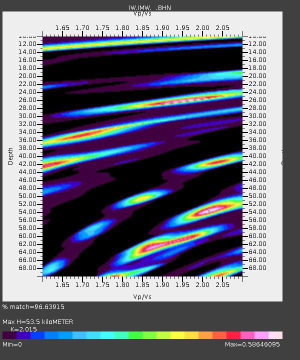
| Estimated Moho Depth: |
53.5 km |
| Estimated Crust Vp/Vs: |
2.02 |
| Assumed Crust Vp: |
6.207 km/s |
| Estimated Crust Vs: |
3.08 km/s |
| Estimated Crust Poisson's Ratio: |
0.34 |
|
| Radial Match: |
96.63915 % |
| Radial Bump: |
331 |
| Transverse Match: |
77.75248 % |
| Transverse Bump: |
400 |
| SOD ConfigId: |
2658 |
| Insert Time: |
2010-03-09 07:17:23.951 +0000 |
| GWidth: |
2.5 |
| Max Bumps: |
400 |
| Tol: |
0.001 |
|
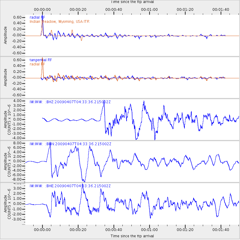
Signal To Noise
| Channel | StoN | STA | LTA |
| IW:IMW: :BHN:20090407T04:33:36.215002Z | 16.096884 | 3.4148866E-6 | 2.121458E-7 |
| IW:IMW: :BHE:20090407T04:33:36.215002Z | 9.95374 | 1.0358467E-6 | 1.04066075E-7 |
| IW:IMW: :BHZ:20090407T04:33:36.215002Z | 8.688382 | 1.5897174E-6 | 1.8297047E-7 |
| Arrivals |
| Ps | 9.1 SECOND |
| PpPs | 25 SECOND |
| PsPs/PpSs | 34 SECOND |


