You are here: Home > Network List > IW - Intermountain West Stations List
> Station IMW Indian Meadow, Wyoming, USA > Earthquake Result Viewer
IMW Indian Meadow, Wyoming, USA - Earthquake Result Viewer
| Earthquake location: |
Central Mid-Atlantic Ridge |
| Earthquake latitude/longitude: |
7.3/-34.9 |
| Earthquake time(UTC): |
2008/05/23 (144) 19:35:34 GMT |
| Earthquake Depth: |
9.0 km |
| Earthquake Magnitude: |
6.0 MB, 6.4 MS, 6.5 MW, 6.5 MW |
| Earthquake Catalog/Contributor: |
WHDF/NEIC |
|
| Network: |
IW Intermountain West |
| Station: |
IMW Indian Meadow, Wyoming, USA |
| Lat/Lon: |
43.90 N/110.94 W |
| Elevation: |
2646 m |
|
| Distance: |
74.9 deg |
| Az: |
313.396 deg |
| Baz: |
94.39 deg |
| Ray Param: |
0.052018322 |
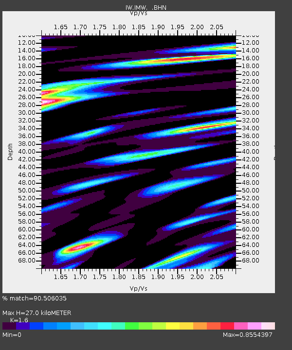
| Estimated Moho Depth: |
27.0 km |
| Estimated Crust Vp/Vs: |
1.60 |
| Assumed Crust Vp: |
6.207 km/s |
| Estimated Crust Vs: |
3.879 km/s |
| Estimated Crust Poisson's Ratio: |
0.18 |
|
| Radial Match: |
90.506035 % |
| Radial Bump: |
388 |
| Transverse Match: |
83.35118 % |
| Transverse Bump: |
343 |
| SOD ConfigId: |
2504 |
| Insert Time: |
2010-03-09 07:17:35.759 +0000 |
| GWidth: |
2.5 |
| Max Bumps: |
400 |
| Tol: |
0.001 |
|

Signal To Noise
| Channel | StoN | STA | LTA |
| IW:IMW: :BHN:20080523T19:46:44.734006Z | 4.266687 | 5.995642E-7 | 1.4052219E-7 |
| IW:IMW: :BHE:20080523T19:46:44.734006Z | 1.6066432 | 3.457239E-7 | 2.15184E-7 |
| IW:IMW: :BHZ:20080523T19:46:44.734006Z | 2.2582843 | 3.544062E-7 | 1.5693604E-7 |
| Arrivals |
| Ps | 2.7 SECOND |
| PpPs | 11 SECOND |
| PsPs/PpSs | 14 SECOND |


