You are here: Home > Network List > IW - Intermountain West Stations List
> Station IMW Indian Meadow, Wyoming, USA > Earthquake Result Viewer
IMW Indian Meadow, Wyoming, USA - Earthquake Result Viewer

| Earthquake location: |
Solomon Islands |
| Earthquake latitude/longitude: |
-10.5/161.3 |
| Earthquake time(UTC): |
2008/06/03 (155) 16:20:50 GMT |
| Earthquake Depth: |
84 km |
| Earthquake Magnitude: |
6.2 MB, 6.2 MW, 6.2 MW |
| Earthquake Catalog/Contributor: |
WHDF/NEIC |
|
| Network: |
IW Intermountain West |
| Station: |
IMW Indian Meadow, Wyoming, USA |
| Lat/Lon: |
43.90 N/110.94 W |
| Elevation: |
2646 m |
|
| Distance: |
95.6 deg |
| Az: |
46.539 deg |
| Baz: |
260.91 deg |
| Ray Param: |
0.0406795 |
| Estimated Moho Depth: |
65.5 km |
| Estimated Crust Vp/Vs: |
1.88 |
| Assumed Crust Vp: |
6.207 km/s |
| Estimated Crust Vs: |
3.306 km/s |
| Estimated Crust Poisson's Ratio: |
0.30 |
|
| Radial Match: |
92.42818 % |
| Radial Bump: |
400 |
| Transverse Match: |
91.90354 % |
| Transverse Bump: |
400 |
| SOD ConfigId: |
2504 |
| Insert Time: |
2010-03-09 07:17:43.739 +0000 |
| GWidth: |
2.5 |
| Max Bumps: |
400 |
| Tol: |
0.001 |
|
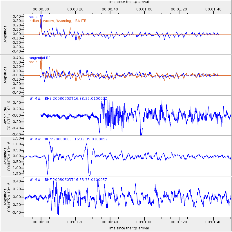
Signal To Noise
| Channel | StoN | STA | LTA |
| IW:IMW: :BHN:20080603T16:33:35.010005Z | 12.399746 | 5.431414E-7 | 4.380263E-8 |
| IW:IMW: :BHE:20080603T16:33:35.010005Z | 1.4660852 | 4.783405E-8 | 3.262706E-8 |
| IW:IMW: :BHZ:20080603T16:33:35.010005Z | 4.7897263 | 1.8175308E-7 | 3.7946442E-8 |
| Arrivals |
| Ps | 9.4 SECOND |
| PpPs | 30 SECOND |
| PsPs/PpSs | 39 SECOND |


