You are here: Home > Network List > IW - Intermountain West Stations List
> Station IMW Indian Meadow, Wyoming, USA > Earthquake Result Viewer
IMW Indian Meadow, Wyoming, USA - Earthquake Result Viewer
| Earthquake location: |
Sea Of Okhotsk |
| Earthquake latitude/longitude: |
53.9/152.9 |
| Earthquake time(UTC): |
2008/07/05 (187) 02:12:04 GMT |
| Earthquake Depth: |
633 km |
| Earthquake Magnitude: |
6.8 MB, 7.7 MW, 7.7 MW |
| Earthquake Catalog/Contributor: |
WHDF/NEIC |
|
| Network: |
IW Intermountain West |
| Station: |
IMW Indian Meadow, Wyoming, USA |
| Lat/Lon: |
43.90 N/110.94 W |
| Elevation: |
2646 m |
|
| Distance: |
59.3 deg |
| Az: |
56.721 deg |
| Baz: |
316.791 deg |
| Ray Param: |
0.05966696 |
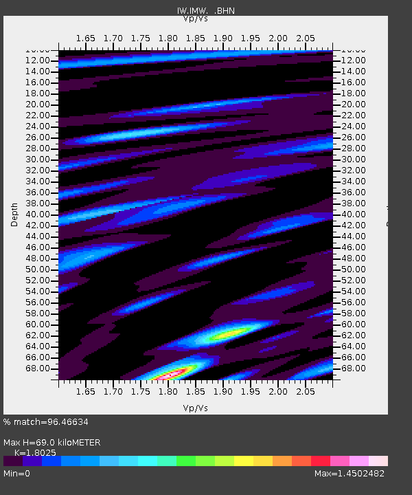
| Estimated Moho Depth: |
69.0 km |
| Estimated Crust Vp/Vs: |
1.80 |
| Assumed Crust Vp: |
6.207 km/s |
| Estimated Crust Vs: |
3.443 km/s |
| Estimated Crust Poisson's Ratio: |
0.28 |
|
| Radial Match: |
96.46634 % |
| Radial Bump: |
400 |
| Transverse Match: |
84.249985 % |
| Transverse Bump: |
400 |
| SOD ConfigId: |
2504 |
| Insert Time: |
2010-03-09 07:17:52.799 +0000 |
| GWidth: |
2.5 |
| Max Bumps: |
400 |
| Tol: |
0.001 |
|
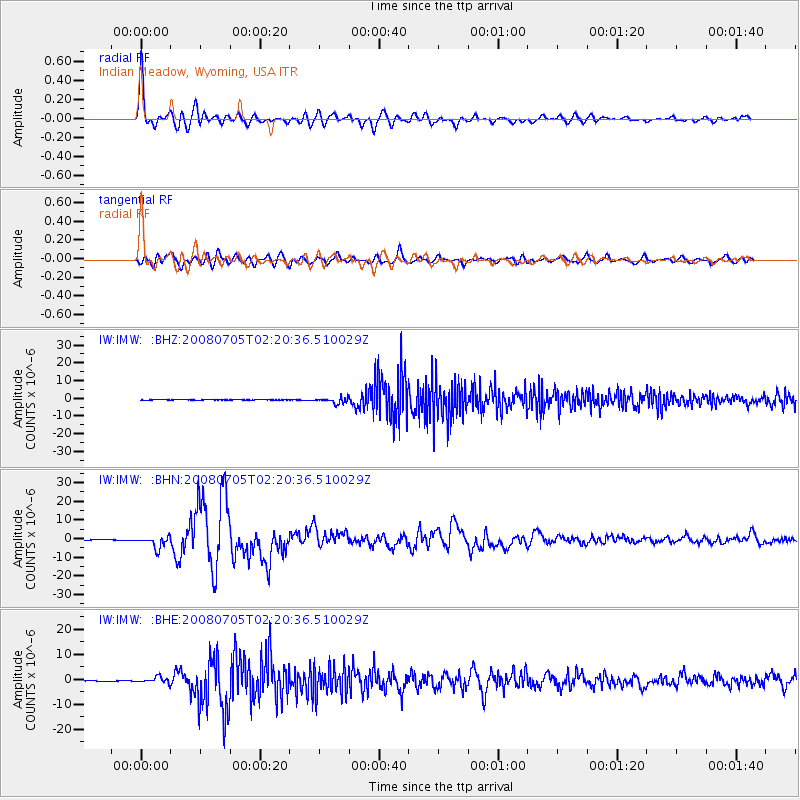
Signal To Noise
| Channel | StoN | STA | LTA |
| IW:IMW: :BHN:20080705T02:20:36.510029Z | 79.883 | 3.1584518E-6 | 3.953847E-8 |
| IW:IMW: :BHE:20080705T02:20:36.510029Z | 18.627346 | 1.2175539E-6 | 6.5363785E-8 |
| IW:IMW: :BHZ:20080705T02:20:36.510029Z | 33.421307 | 1.5934621E-6 | 4.7678036E-8 |
| Arrivals |
| Ps | 9.3 SECOND |
| PpPs | 30 SECOND |
| PsPs/PpSs | 39 SECOND |


