You are here: Home > Network List > AU - Australian Seismological Centre Stations List
> Station PSAA2 Pilbara Seismic Array Element A2 > Earthquake Result Viewer
PSAA2 Pilbara Seismic Array Element A2 - Earthquake Result Viewer
| Earthquake location: |
Iran-Iraq Border Region |
| Earthquake latitude/longitude: |
34.9/46.0 |
| Earthquake time(UTC): |
2017/11/12 (316) 18:18:17 GMT |
| Earthquake Depth: |
19 km |
| Earthquake Magnitude: |
7.3 Mww |
| Earthquake Catalog/Contributor: |
NEIC PDE/us |
|
| Network: |
AU Australian Seismological Centre |
| Station: |
PSAA2 Pilbara Seismic Array Element A2 |
| Lat/Lon: |
21.56 S/119.85 E |
| Elevation: |
330 m |
|
| Distance: |
89.8 deg |
| Az: |
116.58 deg |
| Baz: |
307.849 deg |
| Ray Param: |
0.04172012 |
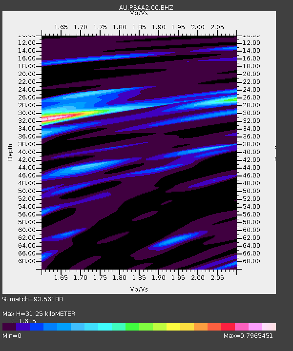
| Estimated Moho Depth: |
31.25 km |
| Estimated Crust Vp/Vs: |
1.62 |
| Assumed Crust Vp: |
6.464 km/s |
| Estimated Crust Vs: |
4.002 km/s |
| Estimated Crust Poisson's Ratio: |
0.19 |
|
| Radial Match: |
93.56188 % |
| Radial Bump: |
341 |
| Transverse Match: |
79.490364 % |
| Transverse Bump: |
400 |
| SOD ConfigId: |
2429771 |
| Insert Time: |
2017-11-26 18:18:25.191 +0000 |
| GWidth: |
2.5 |
| Max Bumps: |
400 |
| Tol: |
0.001 |
|

Signal To Noise
| Channel | StoN | STA | LTA |
| AU:PSAA2:00:BHZ:20171112T18:30:42.818992Z | 30.077654 | 4.5674924E-6 | 1.5185668E-7 |
| AU:PSAA2:00:BH1:20171112T18:30:42.818992Z | 5.0545125 | 1.2971384E-6 | 2.5662976E-7 |
| AU:PSAA2:00:BH2:20171112T18:30:42.818992Z | 3.7911272 | 7.9037954E-7 | 2.0848141E-7 |
| Arrivals |
| Ps | 3.0 SECOND |
| PpPs | 12 SECOND |
| PsPs/PpSs | 15 SECOND |


