You are here: Home > Network List > TA - USArray Transportable Network (new EarthScope stations) Stations List
> Station E20K Nigu River, AK, USA > Earthquake Result Viewer
E20K Nigu River, AK, USA - Earthquake Result Viewer
| Earthquake location: |
Celebes Sea |
| Earthquake latitude/longitude: |
4.1/124.7 |
| Earthquake time(UTC): |
2021/04/10 (100) 09:30:44 GMT |
| Earthquake Depth: |
311 km |
| Earthquake Magnitude: |
6.1 mww |
| Earthquake Catalog/Contributor: |
NEIC PDE/us |
|
| Network: |
TA USArray Transportable Network (new EarthScope stations) |
| Station: |
E20K Nigu River, AK, USA |
| Lat/Lon: |
68.26 N/156.19 W |
| Elevation: |
866 m |
|
| Distance: |
82.2 deg |
| Az: |
21.676 deg |
| Baz: |
261.418 deg |
| Ray Param: |
0.04626028 |
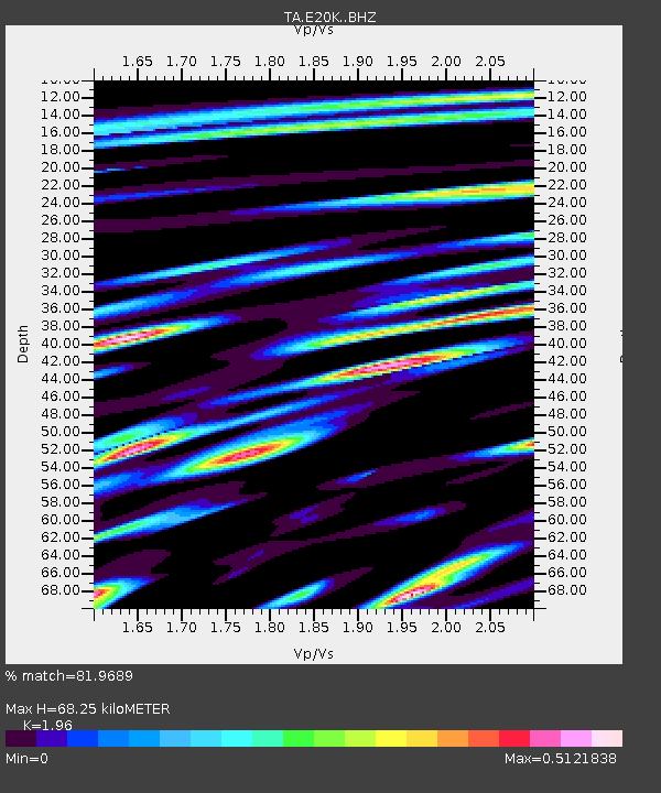
| Estimated Moho Depth: |
68.25 km |
| Estimated Crust Vp/Vs: |
1.96 |
| Assumed Crust Vp: |
6.221 km/s |
| Estimated Crust Vs: |
3.174 km/s |
| Estimated Crust Poisson's Ratio: |
0.32 |
|
| Radial Match: |
81.9689 % |
| Radial Bump: |
400 |
| Transverse Match: |
76.03659 % |
| Transverse Bump: |
400 |
| SOD ConfigId: |
24334971 |
| Insert Time: |
2021-04-24 09:43:11.457 +0000 |
| GWidth: |
2.5 |
| Max Bumps: |
400 |
| Tol: |
0.001 |
|

Signal To Noise
| Channel | StoN | STA | LTA |
| TA:E20K: :BHZ:20210410T09:41:59.499988Z | 19.518473 | 4.059404E-6 | 2.0797755E-7 |
| TA:E20K: :BHN:20210410T09:41:59.499988Z | 1.6210284 | 3.1632982E-7 | 1.9514144E-7 |
| TA:E20K: :BHE:20210410T09:41:59.499988Z | 7.5420766 | 1.209265E-6 | 1.6033582E-7 |
| Arrivals |
| Ps | 11 SECOND |
| PpPs | 32 SECOND |
| PsPs/PpSs | 43 SECOND |


