You are here: Home > Network List > TA - USArray Transportable Network (new EarthScope stations) Stations List
> Station G15K Niukluk, AK, USA > Earthquake Result Viewer
G15K Niukluk, AK, USA - Earthquake Result Viewer
| Earthquake location: |
Celebes Sea |
| Earthquake latitude/longitude: |
4.1/124.7 |
| Earthquake time(UTC): |
2021/04/10 (100) 09:30:44 GMT |
| Earthquake Depth: |
311 km |
| Earthquake Magnitude: |
6.1 mww |
| Earthquake Catalog/Contributor: |
NEIC PDE/us |
|
| Network: |
TA USArray Transportable Network (new EarthScope stations) |
| Station: |
G15K Niukluk, AK, USA |
| Lat/Lon: |
64.99 N/164.04 W |
| Elevation: |
249 m |
|
| Distance: |
78.4 deg |
| Az: |
24.263 deg |
| Baz: |
254.651 deg |
| Ray Param: |
0.048799355 |
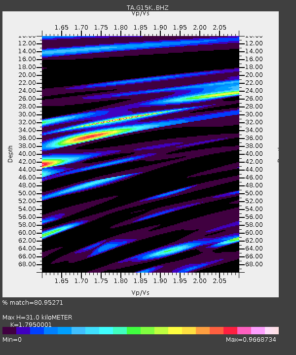
| Estimated Moho Depth: |
31.0 km |
| Estimated Crust Vp/Vs: |
1.80 |
| Assumed Crust Vp: |
6.276 km/s |
| Estimated Crust Vs: |
3.496 km/s |
| Estimated Crust Poisson's Ratio: |
0.27 |
|
| Radial Match: |
80.95271 % |
| Radial Bump: |
400 |
| Transverse Match: |
74.89444 % |
| Transverse Bump: |
400 |
| SOD ConfigId: |
24334971 |
| Insert Time: |
2021-04-24 09:43:31.953 +0000 |
| GWidth: |
2.5 |
| Max Bumps: |
400 |
| Tol: |
0.001 |
|

Signal To Noise
| Channel | StoN | STA | LTA |
| TA:G15K: :BHZ:20210410T09:41:39.775012Z | 7.763486 | 1.634293E-6 | 2.105102E-7 |
| TA:G15K: :BHN:20210410T09:41:39.775012Z | 1.341044 | 1.8786459E-7 | 1.4008832E-7 |
| TA:G15K: :BHE:20210410T09:41:39.775012Z | 3.1605225 | 4.995474E-7 | 1.580585E-7 |
| Arrivals |
| Ps | 4.0 SECOND |
| PpPs | 13 SECOND |
| PsPs/PpSs | 17 SECOND |


