You are here: Home > Network List > TA - USArray Transportable Network (new EarthScope stations) Stations List
> Station H18K Honhosa River, AK, USA > Earthquake Result Viewer
H18K Honhosa River, AK, USA - Earthquake Result Viewer
| Earthquake location: |
Celebes Sea |
| Earthquake latitude/longitude: |
4.1/124.7 |
| Earthquake time(UTC): |
2021/04/10 (100) 09:30:44 GMT |
| Earthquake Depth: |
311 km |
| Earthquake Magnitude: |
6.1 mww |
| Earthquake Catalog/Contributor: |
NEIC PDE/us |
|
| Network: |
TA USArray Transportable Network (new EarthScope stations) |
| Station: |
H18K Honhosa River, AK, USA |
| Lat/Lon: |
65.15 N/158.36 W |
| Elevation: |
494 m |
|
| Distance: |
80.8 deg |
| Az: |
24.644 deg |
| Baz: |
259.86 deg |
| Ray Param: |
0.047187284 |
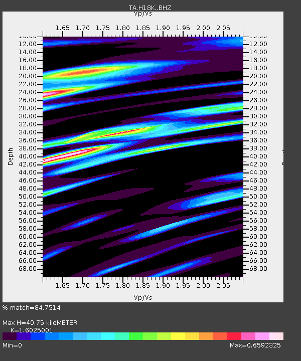
| Estimated Moho Depth: |
40.75 km |
| Estimated Crust Vp/Vs: |
1.60 |
| Assumed Crust Vp: |
6.1 km/s |
| Estimated Crust Vs: |
3.807 km/s |
| Estimated Crust Poisson's Ratio: |
0.18 |
|
| Radial Match: |
84.7514 % |
| Radial Bump: |
298 |
| Transverse Match: |
72.975555 % |
| Transverse Bump: |
351 |
| SOD ConfigId: |
24334971 |
| Insert Time: |
2021-04-24 09:43:41.425 +0000 |
| GWidth: |
2.5 |
| Max Bumps: |
400 |
| Tol: |
0.001 |
|

Signal To Noise
| Channel | StoN | STA | LTA |
| TA:H18K: :BHZ:20210410T09:41:52.450Z | 10.833071 | 3.3793024E-6 | 3.1194318E-7 |
| TA:H18K: :BHN:20210410T09:41:52.450Z | 1.7498478 | 4.3128992E-7 | 2.4647284E-7 |
| TA:H18K: :BHE:20210410T09:41:52.450Z | 5.7324986 | 1.4261632E-6 | 2.4878562E-7 |
| Arrivals |
| Ps | 4.1 SECOND |
| PpPs | 17 SECOND |
| PsPs/PpSs | 21 SECOND |


