You are here: Home > Network List > TA - USArray Transportable Network (new EarthScope stations) Stations List
> Station H31M Peel River, Yukon, CAN > Earthquake Result Viewer
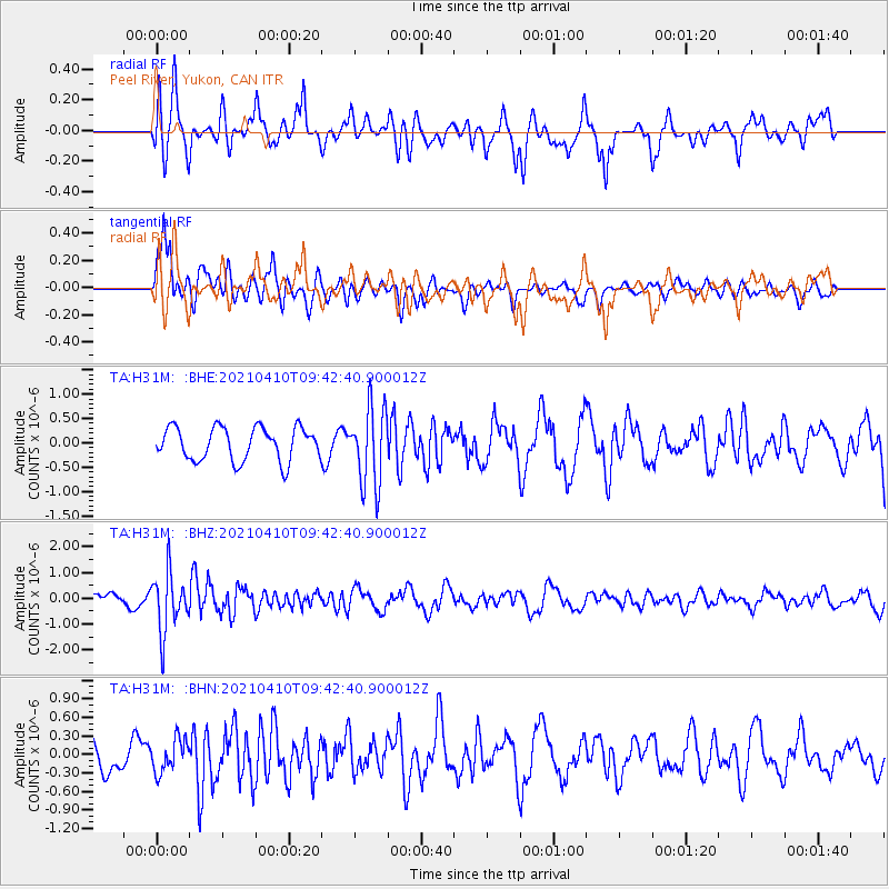
H31M Peel River, Yukon, CAN - Earthquake Result Viewer
*The percent match for this event was below the threshold and hence no stack was calculated.
| Earthquake location: |
Celebes Sea |
| Earthquake latitude/longitude: |
4.1/124.7 |
| Earthquake time(UTC): |
2021/04/10 (100) 09:30:44 GMT |
| Earthquake Depth: |
311 km |
| Earthquake Magnitude: |
6.1 mww |
| Earthquake Catalog/Contributor: |
NEIC PDE/us |
|
| Network: |
TA USArray Transportable Network (new EarthScope stations) |
| Station: |
H31M Peel River, Yukon, CAN |
| Lat/Lon: |
65.81 N/134.34 W |
| Elevation: |
642 m |
|
| Distance: |
90.8 deg |
| Az: |
23.867 deg |
| Baz: |
281.688 deg |
| Ray Param: |
$rayparam |
*The percent match for this event was below the threshold and hence was not used in the summary stack. |
|
| Radial Match: |
69.98287 % |
| Radial Bump: |
370 |
| Transverse Match: |
80.37829 % |
| Transverse Bump: |
400 |
| SOD ConfigId: |
24334971 |
| Insert Time: |
2021-04-24 09:43:47.397 +0000 |
| GWidth: |
2.5 |
| Max Bumps: |
400 |
| Tol: |
0.001 |
|
Signal To Noise
| Channel | StoN | STA | LTA |
| TA:H31M: :BHZ:20210410T09:42:40.900012Z | 3.7378387 | 1.1269977E-6 | 3.0151054E-7 |
| TA:H31M: :BHN:20210410T09:42:40.900012Z | 0.90046746 | 2.666413E-7 | 2.9611434E-7 |
| TA:H31M: :BHE:20210410T09:42:40.900012Z | 2.3545918 | 8.006838E-7 | 3.4005205E-7 |
| Arrivals |
| Ps | |
| PpPs | |
| PsPs/PpSs | |


