You are here: Home > Network List > TA - USArray Transportable Network (new EarthScope stations) Stations List
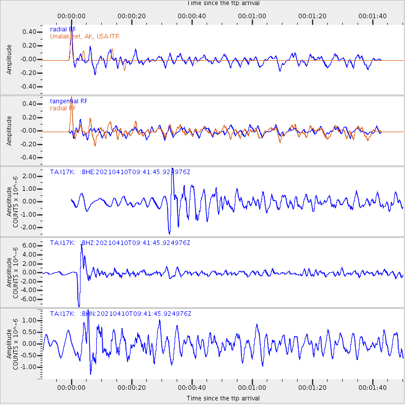
> Station I17K Unalakleet, AK, USA > Earthquake Result Viewer
I17K Unalakleet, AK, USA - Earthquake Result Viewer
| Earthquake location: |
Celebes Sea |
| Earthquake latitude/longitude: |
4.1/124.7 |
| Earthquake time(UTC): |
2021/04/10 (100) 09:30:44 GMT |
| Earthquake Depth: |
311 km |
| Earthquake Magnitude: |
6.1 mww |
| Earthquake Catalog/Contributor: |
NEIC PDE/us |
|
| Network: |
TA USArray Transportable Network (new EarthScope stations) |
| Station: |
I17K Unalakleet, AK, USA |
| Lat/Lon: |
63.89 N/160.70 W |
| Elevation: |
105 m |
|
| Distance: |
79.6 deg |
| Az: |
25.714 deg |
| Baz: |
257.94 deg |
| Ray Param: |
0.048032235 |
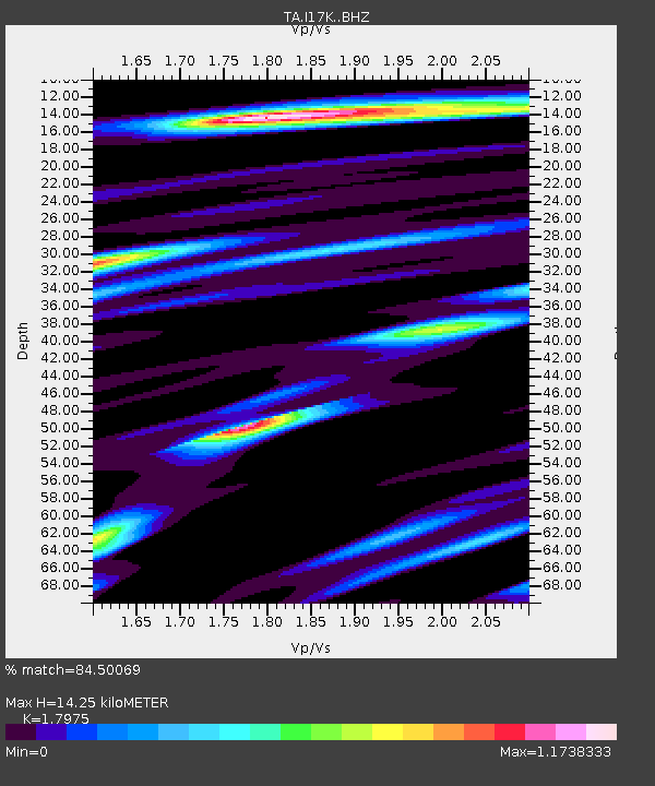
| Estimated Moho Depth: |
14.25 km |
| Estimated Crust Vp/Vs: |
1.80 |
| Assumed Crust Vp: |
6.276 km/s |
| Estimated Crust Vs: |
3.491 km/s |
| Estimated Crust Poisson's Ratio: |
0.28 |
|
| Radial Match: |
84.50069 % |
| Radial Bump: |
395 |
| Transverse Match: |
74.31442 % |
| Transverse Bump: |
389 |
| SOD ConfigId: |
24334971 |
| Insert Time: |
2021-04-24 09:43:48.579 +0000 |
| GWidth: |
2.5 |
| Max Bumps: |
400 |
| Tol: |
0.001 |
|
Signal To Noise
| Channel | StoN | STA | LTA |
| TA:I17K: :BHZ:20210410T09:41:45.924976Z | 18.575174 | 3.3231759E-6 | 1.7890416E-7 |
| TA:I17K: :BHN:20210410T09:41:45.924976Z | 2.0077262 | 4.7289967E-7 | 2.3553991E-7 |
| TA:I17K: :BHE:20210410T09:41:45.924976Z | 4.56698 | 1.2724747E-6 | 2.7862498E-7 |
| Arrivals |
| Ps | 1.9 SECOND |
| PpPs | 6.2 SECOND |
| PsPs/PpSs | 8.0 SECOND |


