You are here: Home > Network List > TA - USArray Transportable Network (new EarthScope stations) Stations List
> Station I30M Mount Dempster, Yukon, CAN > Earthquake Result Viewer
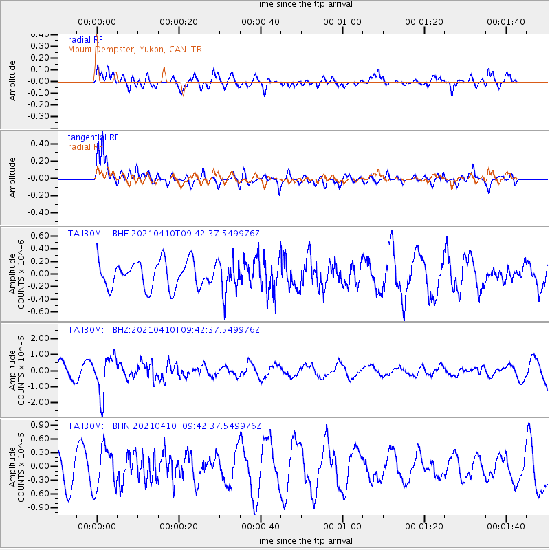
I30M Mount Dempster, Yukon, CAN - Earthquake Result Viewer
*The percent match for this event was below the threshold and hence no stack was calculated.
| Earthquake location: |
Celebes Sea |
| Earthquake latitude/longitude: |
4.1/124.7 |
| Earthquake time(UTC): |
2021/04/10 (100) 09:30:44 GMT |
| Earthquake Depth: |
311 km |
| Earthquake Magnitude: |
6.1 mww |
| Earthquake Catalog/Contributor: |
NEIC PDE/us |
|
| Network: |
TA USArray Transportable Network (new EarthScope stations) |
| Station: |
I30M Mount Dempster, Yukon, CAN |
| Lat/Lon: |
65.22 N/136.38 W |
| Elevation: |
1399 m |
|
| Distance: |
90.1 deg |
| Az: |
24.6 deg |
| Baz: |
279.834 deg |
| Ray Param: |
$rayparam |
*The percent match for this event was below the threshold and hence was not used in the summary stack. |
|
| Radial Match: |
75.41233 % |
| Radial Bump: |
400 |
| Transverse Match: |
84.04516 % |
| Transverse Bump: |
400 |
| SOD ConfigId: |
24334971 |
| Insert Time: |
2021-04-24 09:43:53.982 +0000 |
| GWidth: |
2.5 |
| Max Bumps: |
400 |
| Tol: |
0.001 |
|
Signal To Noise
| Channel | StoN | STA | LTA |
| TA:I30M: :BHZ:20210410T09:42:37.549976Z | 4.034494 | 1.2048748E-6 | 2.9864336E-7 |
| TA:I30M: :BHN:20210410T09:42:37.549976Z | 1.7244363 | 4.524283E-7 | 2.6236302E-7 |
| TA:I30M: :BHE:20210410T09:42:37.549976Z | 1.2542378 | 2.6952785E-7 | 2.1489373E-7 |
| Arrivals |
| Ps | |
| PpPs | |
| PsPs/PpSs | |


