You are here: Home > Network List > TA - USArray Transportable Network (new EarthScope stations) Stations List
> Station J18K Innoko River, AK, USA > Earthquake Result Viewer
J18K Innoko River, AK, USA - Earthquake Result Viewer
| Earthquake location: |
Celebes Sea |
| Earthquake latitude/longitude: |
4.1/124.7 |
| Earthquake time(UTC): |
2021/04/10 (100) 09:30:44 GMT |
| Earthquake Depth: |
311 km |
| Earthquake Magnitude: |
6.1 mww |
| Earthquake Catalog/Contributor: |
NEIC PDE/us |
|
| Network: |
TA USArray Transportable Network (new EarthScope stations) |
| Station: |
J18K Innoko River, AK, USA |
| Lat/Lon: |
63.47 N/156.72 W |
| Elevation: |
506 m |
|
| Distance: |
81.3 deg |
| Az: |
26.455 deg |
| Baz: |
261.626 deg |
| Ray Param: |
0.046890613 |
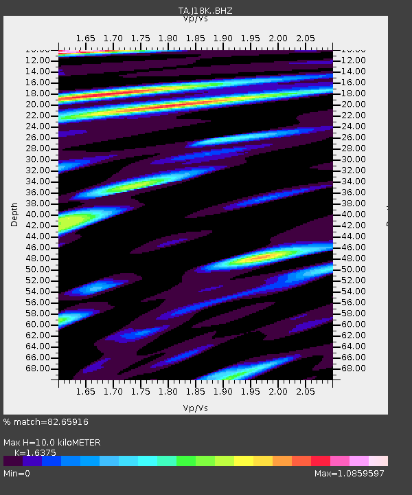
| Estimated Moho Depth: |
10.0 km |
| Estimated Crust Vp/Vs: |
1.64 |
| Assumed Crust Vp: |
6.182 km/s |
| Estimated Crust Vs: |
3.775 km/s |
| Estimated Crust Poisson's Ratio: |
0.20 |
|
| Radial Match: |
82.65916 % |
| Radial Bump: |
400 |
| Transverse Match: |
72.27338 % |
| Transverse Bump: |
400 |
| SOD ConfigId: |
24334971 |
| Insert Time: |
2021-04-24 09:43:58.359 +0000 |
| GWidth: |
2.5 |
| Max Bumps: |
400 |
| Tol: |
0.001 |
|

Signal To Noise
| Channel | StoN | STA | LTA |
| TA:J18K: :BHZ:20210410T09:41:54.725024Z | 14.863016 | 3.1251495E-6 | 2.1026348E-7 |
| TA:J18K: :BHN:20210410T09:41:54.725024Z | 1.6423306 | 3.3335024E-7 | 2.029739E-7 |
| TA:J18K: :BHE:20210410T09:41:54.725024Z | 4.474225 | 1.0864976E-6 | 2.428348E-7 |
| Arrivals |
| Ps | 1.1 SECOND |
| PpPs | 4.2 SECOND |
| PsPs/PpSs | 5.2 SECOND |


