You are here: Home > Network List > TA - USArray Transportable Network (new EarthScope stations) Stations List
> Station L15K Ungalak Mountain, AK, USA > Earthquake Result Viewer
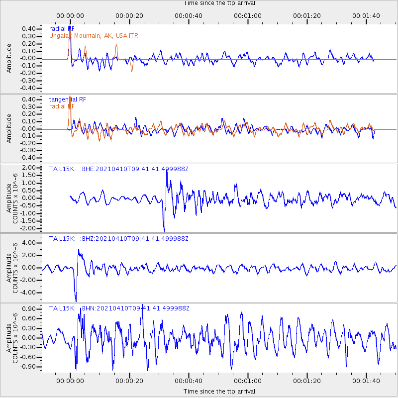
L15K Ungalak Mountain, AK, USA - Earthquake Result Viewer
*The percent match for this event was below the threshold and hence no stack was calculated.
| Earthquake location: |
Celebes Sea |
| Earthquake latitude/longitude: |
4.1/124.7 |
| Earthquake time(UTC): |
2021/04/10 (100) 09:30:44 GMT |
| Earthquake Depth: |
311 km |
| Earthquake Magnitude: |
6.1 mww |
| Earthquake Catalog/Contributor: |
NEIC PDE/us |
|
| Network: |
TA USArray Transportable Network (new EarthScope stations) |
| Station: |
L15K Ungalak Mountain, AK, USA |
| Lat/Lon: |
61.68 N/161.49 W |
| Elevation: |
219 m |
|
| Distance: |
78.8 deg |
| Az: |
27.841 deg |
| Baz: |
257.636 deg |
| Ray Param: |
$rayparam |
*The percent match for this event was below the threshold and hence was not used in the summary stack. |
|
| Radial Match: |
65.73538 % |
| Radial Bump: |
400 |
| Transverse Match: |
56.829956 % |
| Transverse Bump: |
400 |
| SOD ConfigId: |
24334971 |
| Insert Time: |
2021-04-24 09:44:03.128 +0000 |
| GWidth: |
2.5 |
| Max Bumps: |
400 |
| Tol: |
0.001 |
|
Signal To Noise
| Channel | StoN | STA | LTA |
| TA:L15K: :BHZ:20210410T09:41:41.499988Z | 8.547387 | 2.1506748E-6 | 2.5161782E-7 |
| TA:L15K: :BHN:20210410T09:41:41.499988Z | 1.3532491 | 4.6162694E-7 | 3.4112492E-7 |
| TA:L15K: :BHE:20210410T09:41:41.499988Z | 4.3209367 | 8.957147E-7 | 2.0729642E-7 |
| Arrivals |
| Ps | |
| PpPs | |
| PsPs/PpSs | |


