You are here: Home > Network List > G - GEOSCOPE Stations List
> Station CRZF Port Alfred, Crozet, South Indian Ocean > Earthquake Result Viewer
CRZF Port Alfred, Crozet, South Indian Ocean - Earthquake Result Viewer
| Earthquake location: |
Iran-Iraq Border Region |
| Earthquake latitude/longitude: |
34.9/46.0 |
| Earthquake time(UTC): |
2017/11/12 (316) 18:18:17 GMT |
| Earthquake Depth: |
19 km |
| Earthquake Magnitude: |
7.3 Mww |
| Earthquake Catalog/Contributor: |
NEIC PDE/us |
|
| Network: |
G GEOSCOPE |
| Station: |
CRZF Port Alfred, Crozet, South Indian Ocean |
| Lat/Lon: |
46.43 S/51.86 E |
| Elevation: |
140 m |
|
| Distance: |
81.1 deg |
| Az: |
175.87 deg |
| Baz: |
355.091 deg |
| Ray Param: |
0.047781292 |
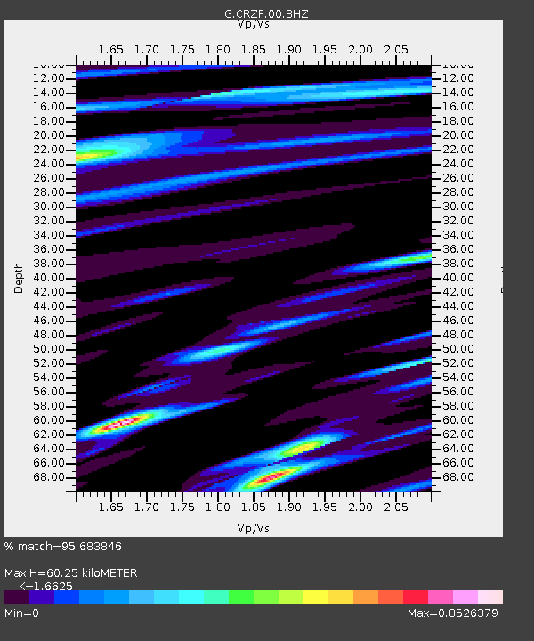
| Estimated Moho Depth: |
60.25 km |
| Estimated Crust Vp/Vs: |
1.66 |
| Assumed Crust Vp: |
4.802 km/s |
| Estimated Crust Vs: |
2.888 km/s |
| Estimated Crust Poisson's Ratio: |
0.22 |
|
| Radial Match: |
95.683846 % |
| Radial Bump: |
367 |
| Transverse Match: |
91.492226 % |
| Transverse Bump: |
400 |
| SOD ConfigId: |
2429771 |
| Insert Time: |
2017-11-26 18:19:09.439 +0000 |
| GWidth: |
2.5 |
| Max Bumps: |
400 |
| Tol: |
0.001 |
|
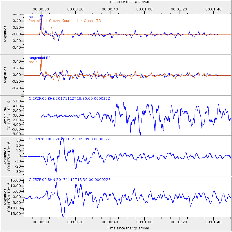
Signal To Noise
| Channel | StoN | STA | LTA |
| G:CRZF:00:BHZ:20171112T18:30:00.000022Z | 15.8684 | 6.4331425E-6 | 4.054059E-7 |
| G:CRZF:00:BHN:20171112T18:30:00.000022Z | 4.0115614 | 2.5066577E-6 | 6.2485833E-7 |
| G:CRZF:00:BHE:20171112T18:30:00.000022Z | 2.8583333 | 9.152338E-7 | 3.2019838E-7 |
| Arrivals |
| Ps | 8.4 SECOND |
| PpPs | 33 SECOND |
| PsPs/PpSs | 41 SECOND |


