You are here: Home > Network List > IW - Intermountain West Stations List
> Station IMW Indian Meadow, Wyoming, USA > Earthquake Result Viewer
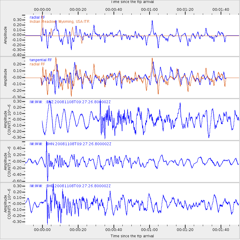
IMW Indian Meadow, Wyoming, USA - Earthquake Result Viewer
*The percent match for this event was below the threshold and hence no stack was calculated.
| Earthquake location: |
Tonga Islands |
| Earthquake latitude/longitude: |
-15.2/-174.2 |
| Earthquake time(UTC): |
2008/11/08 (313) 09:15:51 GMT |
| Earthquake Depth: |
140 km |
| Earthquake Magnitude: |
5.5 MW, 5.3 MB |
| Earthquake Catalog/Contributor: |
WHDF/NEIC |
|
| Network: |
IW Intermountain West |
| Station: |
IMW Indian Meadow, Wyoming, USA |
| Lat/Lon: |
43.90 N/110.94 W |
| Elevation: |
2646 m |
|
| Distance: |
82.3 deg |
| Az: |
40.656 deg |
| Baz: |
240.462 deg |
| Ray Param: |
$rayparam |
*The percent match for this event was below the threshold and hence was not used in the summary stack. |
|
| Radial Match: |
52.22966 % |
| Radial Bump: |
400 |
| Transverse Match: |
51.43076 % |
| Transverse Bump: |
367 |
| SOD ConfigId: |
2658 |
| Insert Time: |
2010-03-09 07:19:07.462 +0000 |
| GWidth: |
2.5 |
| Max Bumps: |
400 |
| Tol: |
0.001 |
|
Signal To Noise
| Channel | StoN | STA | LTA |
| IW:IMW: :BHN:20081108T09:27:26.800002Z | 2.0022197 | 2.2268767E-7 | 1.11220395E-7 |
| IW:IMW: :BHE:20081108T09:27:26.800002Z | 1.4582711 | 1.19115604E-7 | 8.168275E-8 |
| IW:IMW: :BHZ:20081108T09:27:26.800002Z | 0.7778324 | 1.04235326E-7 | 1.3400744E-7 |
| Arrivals |
| Ps | |
| PpPs | |
| PsPs/PpSs | |


