You are here: Home > Network List > PS - Pacific21 Stations List
> Station PSI Parapat, Indonesia > Earthquake Result Viewer
PSI Parapat, Indonesia - Earthquake Result Viewer
| Earthquake location: |
Near N Coast Of New Guinea, P.N.G. |
| Earthquake latitude/longitude: |
-3.5/145.7 |
| Earthquake time(UTC): |
2021/04/10 (100) 11:38:32 GMT |
| Earthquake Depth: |
10 km |
| Earthquake Magnitude: |
6.0 mww |
| Earthquake Catalog/Contributor: |
NEIC PDE/us |
|
| Network: |
PS Pacific21 |
| Station: |
PSI Parapat, Indonesia |
| Lat/Lon: |
2.69 N/98.92 E |
| Elevation: |
987 m |
|
| Distance: |
47.2 deg |
| Az: |
276.853 deg |
| Baz: |
97.18 deg |
| Ray Param: |
0.07017451 |
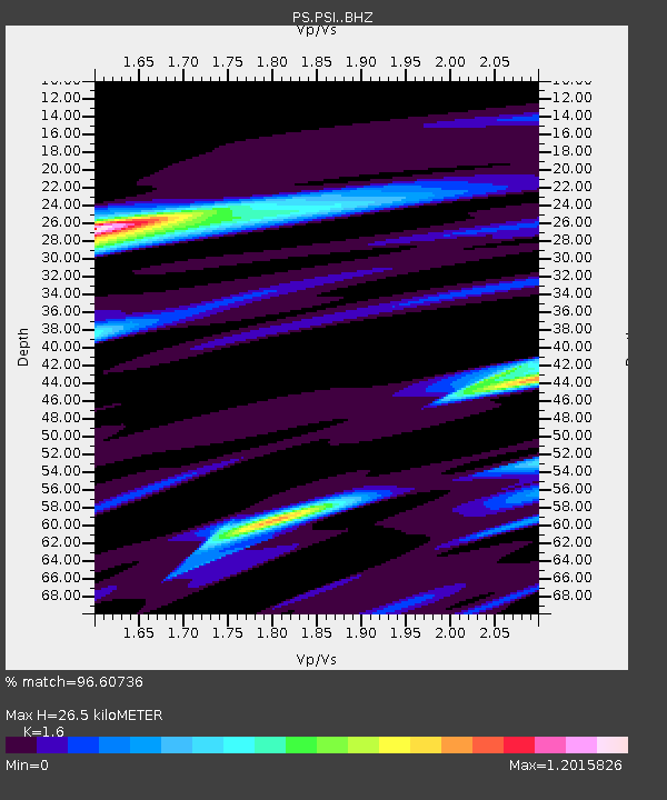
| Estimated Moho Depth: |
26.5 km |
| Estimated Crust Vp/Vs: |
1.60 |
| Assumed Crust Vp: |
6.468 km/s |
| Estimated Crust Vs: |
4.042 km/s |
| Estimated Crust Poisson's Ratio: |
0.18 |
|
| Radial Match: |
96.60736 % |
| Radial Bump: |
398 |
| Transverse Match: |
87.23643 % |
| Transverse Bump: |
400 |
| SOD ConfigId: |
24334971 |
| Insert Time: |
2021-04-24 11:48:48.965 +0000 |
| GWidth: |
2.5 |
| Max Bumps: |
400 |
| Tol: |
0.001 |
|
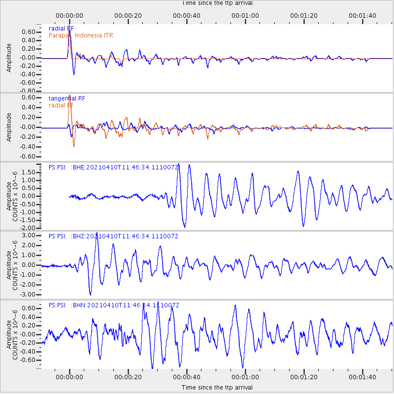
Signal To Noise
| Channel | StoN | STA | LTA |
| PS:PSI: :BHZ:20210410T11:46:34.111007Z | 3.7154503 | 3.2740184E-7 | 8.8119016E-8 |
| PS:PSI: :BHN:20210410T11:46:34.111007Z | 0.96805847 | 9.063347E-8 | 9.362397E-8 |
| PS:PSI: :BHE:20210410T11:46:34.111007Z | 2.9938974 | 2.3744353E-7 | 7.9309174E-8 |
| Arrivals |
| Ps | 2.6 SECOND |
| PpPs | 9.9 SECOND |
| PsPs/PpSs | 13 SECOND |


