You are here: Home > Network List > IW - Intermountain West Stations List
> Station IMW Indian Meadow, Wyoming, USA > Earthquake Result Viewer
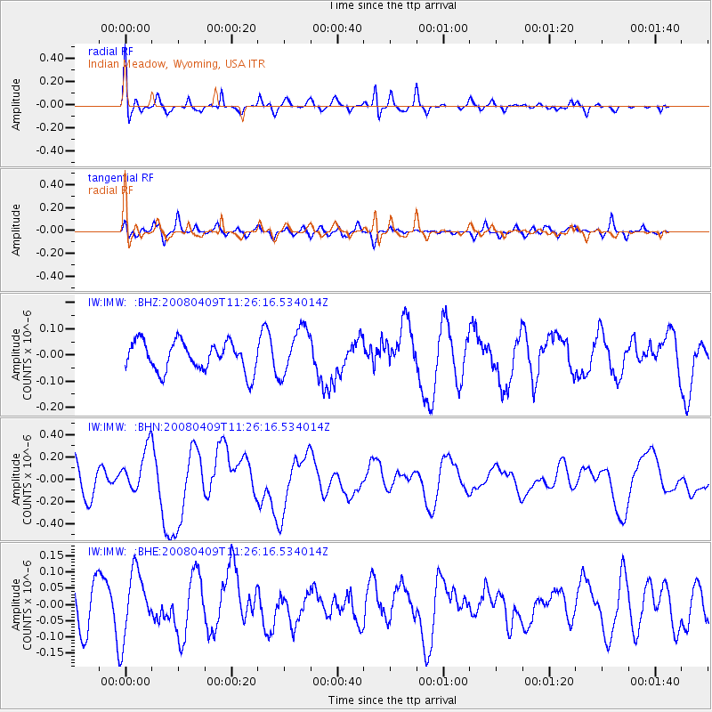
IMW Indian Meadow, Wyoming, USA - Earthquake Result Viewer
*The percent match for this event was below the threshold and hence no stack was calculated.
| Earthquake location: |
Loyalty Islands |
| Earthquake latitude/longitude: |
-20.2/168.9 |
| Earthquake time(UTC): |
2008/04/09 (100) 11:13:17 GMT |
| Earthquake Depth: |
13 km |
| Earthquake Magnitude: |
5.6 MB, 6.3 MS, 6.4 MW, 6.3 MW |
| Earthquake Catalog/Contributor: |
WHDF/NEIC |
|
| Network: |
IW Intermountain West |
| Station: |
IMW Indian Meadow, Wyoming, USA |
| Lat/Lon: |
43.90 N/110.94 W |
| Elevation: |
2646 m |
|
| Distance: |
97.0 deg |
| Az: |
45.862 deg |
| Baz: |
248.839 deg |
| Ray Param: |
$rayparam |
*The percent match for this event was below the threshold and hence was not used in the summary stack. |
|
| Radial Match: |
63.656834 % |
| Radial Bump: |
400 |
| Transverse Match: |
53.55439 % |
| Transverse Bump: |
400 |
| SOD ConfigId: |
2504 |
| Insert Time: |
2010-03-09 07:19:25.471 +0000 |
| GWidth: |
2.5 |
| Max Bumps: |
400 |
| Tol: |
0.001 |
|
Signal To Noise
| Channel | StoN | STA | LTA |
| IW:IMW: :BHN:20080409T11:26:16.534014Z | 1.793054 | 2.040662E-7 | 1.13809286E-7 |
| IW:IMW: :BHE:20080409T11:26:16.534014Z | 1.5222678 | 9.923299E-8 | 6.51876E-8 |
| IW:IMW: :BHZ:20080409T11:26:16.534014Z | 1.6131704 | 9.0249664E-8 | 5.5945524E-8 |
| Arrivals |
| Ps | |
| PpPs | |
| PsPs/PpSs | |


