You are here: Home > Network List > IW - Intermountain West Stations List
> Station LOHW Long Hollow, Wyoming, USA > Earthquake Result Viewer
LOHW Long Hollow, Wyoming, USA - Earthquake Result Viewer
| Earthquake location: |
Near Coast Of Nicaragua |
| Earthquake latitude/longitude: |
11.2/-86.2 |
| Earthquake time(UTC): |
2005/07/02 (183) 02:16:43 GMT |
| Earthquake Depth: |
27 km |
| Earthquake Magnitude: |
5.6 MB, 6.4 MS, 6.6 MW, 6.6 MW |
| Earthquake Catalog/Contributor: |
WHDF/NEIC |
|
| Network: |
IW Intermountain West |
| Station: |
LOHW Long Hollow, Wyoming, USA |
| Lat/Lon: |
43.61 N/110.60 W |
| Elevation: |
2121 m |
|
| Distance: |
38.6 deg |
| Az: |
331.188 deg |
| Baz: |
139.387 deg |
| Ray Param: |
0.075444154 |
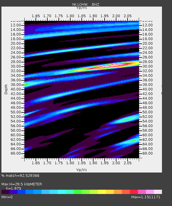
| Estimated Moho Depth: |
29.5 km |
| Estimated Crust Vp/Vs: |
1.98 |
| Assumed Crust Vp: |
6.207 km/s |
| Estimated Crust Vs: |
3.143 km/s |
| Estimated Crust Poisson's Ratio: |
0.33 |
|
| Radial Match: |
92.529366 % |
| Radial Bump: |
400 |
| Transverse Match: |
78.794754 % |
| Transverse Bump: |
400 |
| SOD ConfigId: |
3128 |
| Insert Time: |
2010-03-09 07:19:44.322 +0000 |
| GWidth: |
2.5 |
| Max Bumps: |
400 |
| Tol: |
0.001 |
|

Signal To Noise
| Channel | StoN | STA | LTA |
| IW:LOHW: :BHZ:20050702T02:23:33.465015Z | 73.63704 | 2.1561793E-6 | 2.9281178E-8 |
| IW:LOHW: :BHN:20050702T02:23:33.465015Z | 34.131832 | 1.1396959E-6 | 3.3391E-8 |
| IW:LOHW: :BHE:20050702T02:23:33.465015Z | 18.410246 | 7.075208E-7 | 3.843082E-8 |
| Arrivals |
| Ps | 4.9 SECOND |
| PpPs | 13 SECOND |
| PsPs/PpSs | 18 SECOND |


