You are here: Home > Network List > II - Global Seismograph Network (GSN - IRIS/IDA) Stations List
> Station CMLA Cha de Macela, Sao Miguel Island, Azores > Earthquake Result Viewer
CMLA Cha de Macela, Sao Miguel Island, Azores - Earthquake Result Viewer
| Earthquake location: |
Iran-Iraq Border Region |
| Earthquake latitude/longitude: |
34.9/46.0 |
| Earthquake time(UTC): |
2017/11/12 (316) 18:18:17 GMT |
| Earthquake Depth: |
19 km |
| Earthquake Magnitude: |
7.3 Mww |
| Earthquake Catalog/Contributor: |
NEIC PDE/us |
|
| Network: |
II Global Seismograph Network (GSN - IRIS/IDA) |
| Station: |
CMLA Cha de Macela, Sao Miguel Island, Azores |
| Lat/Lon: |
37.76 N/25.52 W |
| Elevation: |
429 m |
|
| Distance: |
56.3 deg |
| Az: |
295.462 deg |
| Baz: |
69.444 deg |
| Ray Param: |
0.064185195 |
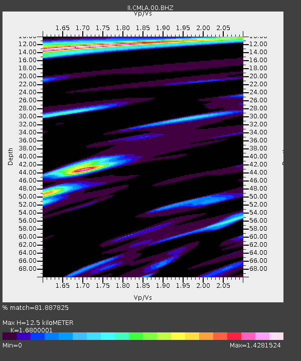
| Estimated Moho Depth: |
12.5 km |
| Estimated Crust Vp/Vs: |
1.68 |
| Assumed Crust Vp: |
4.802 km/s |
| Estimated Crust Vs: |
2.858 km/s |
| Estimated Crust Poisson's Ratio: |
0.23 |
|
| Radial Match: |
81.887825 % |
| Radial Bump: |
354 |
| Transverse Match: |
81.39764 % |
| Transverse Bump: |
346 |
| SOD ConfigId: |
2429771 |
| Insert Time: |
2017-11-26 18:19:58.249 +0000 |
| GWidth: |
2.5 |
| Max Bumps: |
400 |
| Tol: |
0.001 |
|
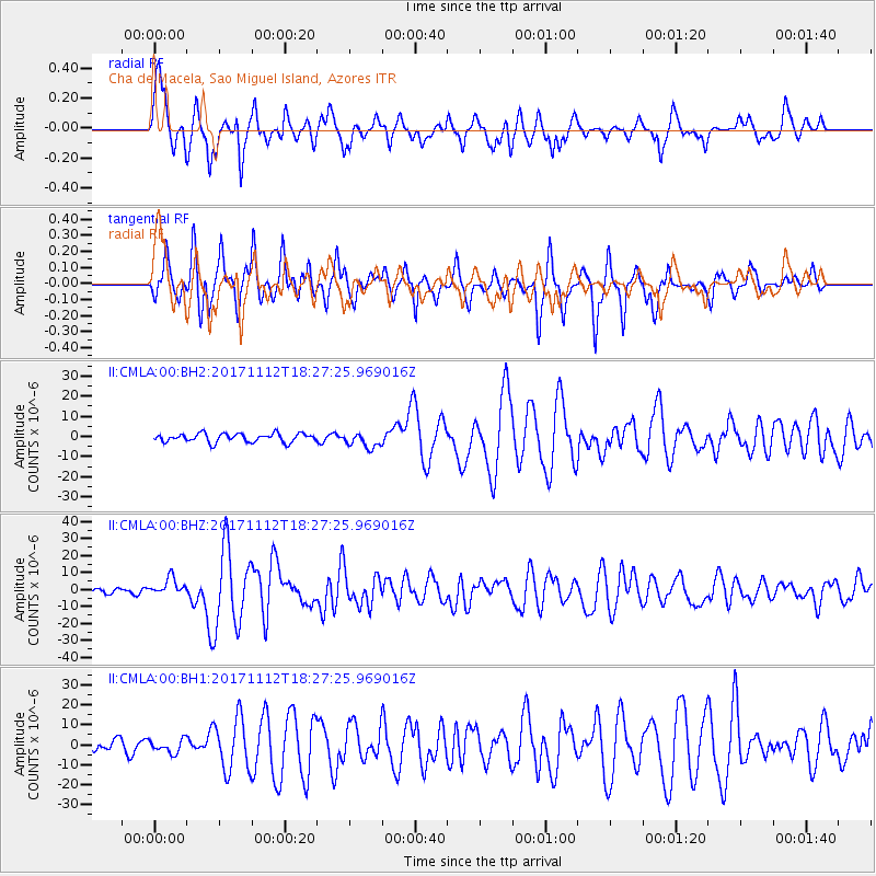
Signal To Noise
| Channel | StoN | STA | LTA |
| II:CMLA:00:BHZ:20171112T18:27:25.969016Z | 3.3541934 | 5.20127E-6 | 1.5506769E-6 |
| II:CMLA:00:BH1:20171112T18:27:25.969016Z | 1.7250382 | 3.3743368E-6 | 1.956094E-6 |
| II:CMLA:00:BH2:20171112T18:27:25.969016Z | 1.7776431 | 3.7967898E-6 | 2.135856E-6 |
| Arrivals |
| Ps | 1.8 SECOND |
| PpPs | 6.8 SECOND |
| PsPs/PpSs | 8.6 SECOND |


