You are here: Home > Network List > IU - Global Seismograph Network (GSN - IRIS/USGS) Stations List
> Station INCN Inchon, Republic of Korea > Earthquake Result Viewer
INCN Inchon, Republic of Korea - Earthquake Result Viewer
| Earthquake location: |
Iran-Iraq Border Region |
| Earthquake latitude/longitude: |
34.9/46.0 |
| Earthquake time(UTC): |
2017/11/12 (316) 18:18:17 GMT |
| Earthquake Depth: |
19 km |
| Earthquake Magnitude: |
7.3 Mww |
| Earthquake Catalog/Contributor: |
NEIC PDE/us |
|
| Network: |
IU Global Seismograph Network (GSN - IRIS/USGS) |
| Station: |
INCN Inchon, Republic of Korea |
| Lat/Lon: |
37.48 N/126.62 E |
| Elevation: |
55 m |
|
| Distance: |
63.2 deg |
| Az: |
61.599 deg |
| Baz: |
294.665 deg |
| Ray Param: |
0.05972326 |
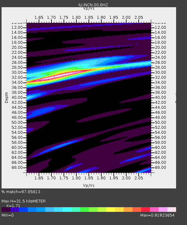
| Estimated Moho Depth: |
31.5 km |
| Estimated Crust Vp/Vs: |
1.71 |
| Assumed Crust Vp: |
6.459 km/s |
| Estimated Crust Vs: |
3.777 km/s |
| Estimated Crust Poisson's Ratio: |
0.24 |
|
| Radial Match: |
97.85813 % |
| Radial Bump: |
192 |
| Transverse Match: |
90.92627 % |
| Transverse Bump: |
400 |
| SOD ConfigId: |
2429771 |
| Insert Time: |
2017-11-26 18:20:21.003 +0000 |
| GWidth: |
2.5 |
| Max Bumps: |
400 |
| Tol: |
0.001 |
|

Signal To Noise
| Channel | StoN | STA | LTA |
| IU:INCN:00:BHZ:20171112T18:28:12.919028Z | 86.85088 | 2.2624561E-5 | 2.6049892E-7 |
| IU:INCN:00:BH1:20171112T18:28:12.919028Z | 26.923409 | 4.3925947E-6 | 1.6315151E-7 |
| IU:INCN:00:BH2:20171112T18:28:12.919028Z | 52.381725 | 9.945992E-6 | 1.8987524E-7 |
| Arrivals |
| Ps | 3.6 SECOND |
| PpPs | 13 SECOND |
| PsPs/PpSs | 16 SECOND |


