You are here: Home > Network List > IU - Global Seismograph Network (GSN - IRIS/USGS) Stations List
> Station KMBO Kilima Mbogo, Kenya > Earthquake Result Viewer
KMBO Kilima Mbogo, Kenya - Earthquake Result Viewer
| Earthquake location: |
Iran-Iraq Border Region |
| Earthquake latitude/longitude: |
34.9/46.0 |
| Earthquake time(UTC): |
2017/11/12 (316) 18:18:17 GMT |
| Earthquake Depth: |
19 km |
| Earthquake Magnitude: |
7.3 Mww |
| Earthquake Catalog/Contributor: |
NEIC PDE/us |
|
| Network: |
IU Global Seismograph Network (GSN - IRIS/USGS) |
| Station: |
KMBO Kilima Mbogo, Kenya |
| Lat/Lon: |
1.13 S/37.25 E |
| Elevation: |
1950 m |
|
| Distance: |
36.8 deg |
| Az: |
194.644 deg |
| Baz: |
11.995 deg |
| Ray Param: |
0.07648318 |
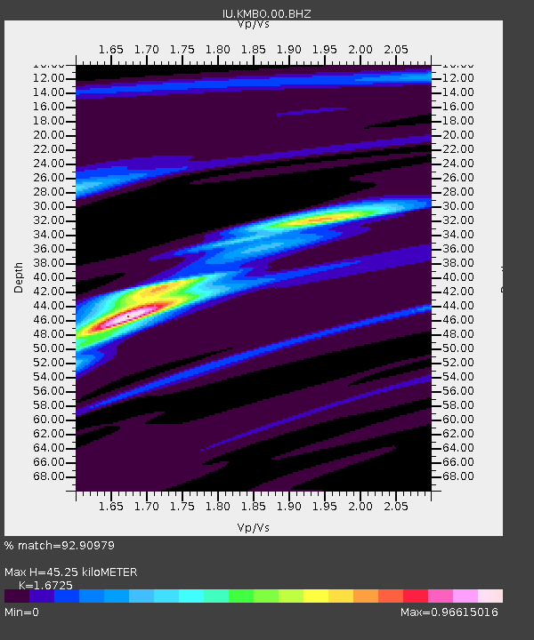
| Estimated Moho Depth: |
45.25 km |
| Estimated Crust Vp/Vs: |
1.67 |
| Assumed Crust Vp: |
6.601 km/s |
| Estimated Crust Vs: |
3.947 km/s |
| Estimated Crust Poisson's Ratio: |
0.22 |
|
| Radial Match: |
92.90979 % |
| Radial Bump: |
132 |
| Transverse Match: |
67.96439 % |
| Transverse Bump: |
372 |
| SOD ConfigId: |
2429771 |
| Insert Time: |
2017-11-26 18:20:23.514 +0000 |
| GWidth: |
2.5 |
| Max Bumps: |
400 |
| Tol: |
0.001 |
|

Signal To Noise
| Channel | StoN | STA | LTA |
| IU:KMBO:00:BHZ:20171112T18:24:52.769004Z | 58.373486 | 1.9810268E-5 | 3.3937098E-7 |
| IU:KMBO:00:BH1:20171112T18:24:52.769004Z | 41.329254 | 1.1240416E-5 | 2.7197237E-7 |
| IU:KMBO:00:BH2:20171112T18:24:52.769004Z | 49.97264 | 3.615911E-6 | 7.2357814E-8 |
| Arrivals |
| Ps | 5.0 SECOND |
| PpPs | 17 SECOND |
| PsPs/PpSs | 22 SECOND |


