You are here: Home > Network List > AV - Alaska Volcano Observatory Stations List
> Station MAPS Pakushin Southeast, Makushin Volcano, Alaska > Earthquake Result Viewer
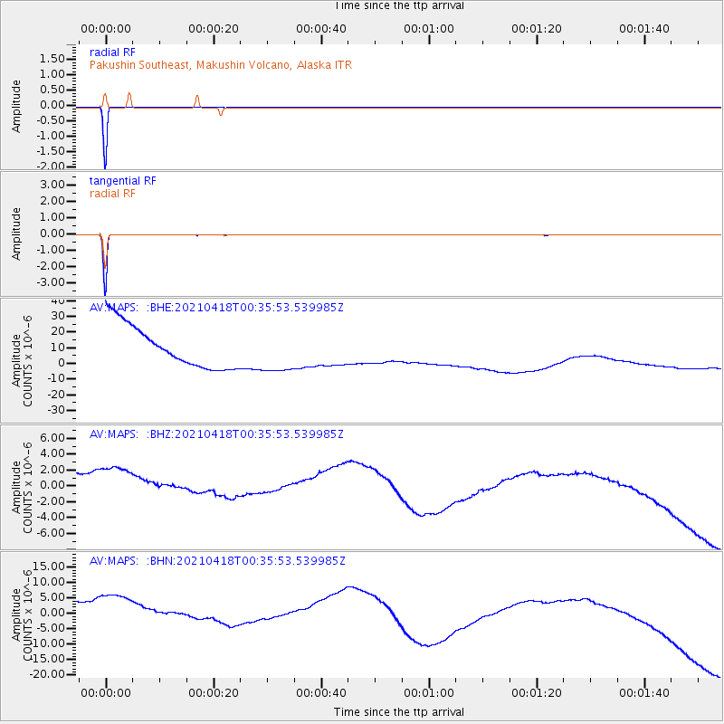
MAPS Pakushin Southeast, Makushin Volcano, Alaska - Earthquake Result Viewer
*The percent match for this event was below the threshold and hence no stack was calculated.
| Earthquake location: |
Near East Coast Of Honshu, Japan |
| Earthquake latitude/longitude: |
38.4/141.9 |
| Earthquake time(UTC): |
2021/04/18 (108) 00:29:12 GMT |
| Earthquake Depth: |
52 km |
| Earthquake Magnitude: |
5.6 mww |
| Earthquake Catalog/Contributor: |
NEIC PDE/us |
|
| Network: |
AV Alaska Volcano Observatory |
| Station: |
MAPS Pakushin Southeast, Makushin Volcano, Alaska |
| Lat/Lon: |
53.81 N/166.94 W |
| Elevation: |
333 m |
|
| Distance: |
37.8 deg |
| Az: |
48.89 deg |
| Baz: |
267.147 deg |
| Ray Param: |
$rayparam |
*The percent match for this event was below the threshold and hence was not used in the summary stack. |
|
| Radial Match: |
99.92086 % |
| Radial Bump: |
6 |
| Transverse Match: |
99.95068 % |
| Transverse Bump: |
10 |
| SOD ConfigId: |
24334971 |
| Insert Time: |
2021-05-02 00:36:20.524 +0000 |
| GWidth: |
2.5 |
| Max Bumps: |
400 |
| Tol: |
0.001 |
|
Signal To Noise
| Channel | StoN | STA | LTA |
| AV:MAPS: :BHZ:20210418T00:35:53.539985Z | 1.0496671 | 9.001349E-6 | 8.575433E-6 |
| AV:MAPS: :BHN:20210418T00:35:53.539985Z | 1.0648258 | 2.3674866E-5 | 2.2233558E-5 |
| AV:MAPS: :BHE:20210418T00:35:53.539985Z | 1.0364026 | 1.4072194E-5 | 1.3577923E-5 |
| Arrivals |
| Ps | |
| PpPs | |
| PsPs/PpSs | |


