You are here: Home > Network List > NE - New England Seismic Network Stations List
> Station WES Weston Observatory, Weston, MA, USA > Earthquake Result Viewer
WES Weston Observatory, Weston, MA, USA - Earthquake Result Viewer
| Earthquake location: |
Iran-Iraq Border Region |
| Earthquake latitude/longitude: |
34.9/46.0 |
| Earthquake time(UTC): |
2017/11/12 (316) 18:18:17 GMT |
| Earthquake Depth: |
19 km |
| Earthquake Magnitude: |
7.3 Mww |
| Earthquake Catalog/Contributor: |
NEIC PDE/us |
|
| Network: |
NE New England Seismic Network |
| Station: |
WES Weston Observatory, Weston, MA, USA |
| Lat/Lon: |
42.38 N/71.32 W |
| Elevation: |
60 m |
|
| Distance: |
84.1 deg |
| Az: |
318.544 deg |
| Baz: |
47.26 deg |
| Ray Param: |
0.045732144 |
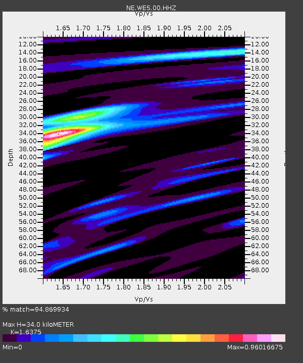
| Estimated Moho Depth: |
34.0 km |
| Estimated Crust Vp/Vs: |
1.64 |
| Assumed Crust Vp: |
6.419 km/s |
| Estimated Crust Vs: |
3.92 km/s |
| Estimated Crust Poisson's Ratio: |
0.20 |
|
| Radial Match: |
94.869934 % |
| Radial Bump: |
400 |
| Transverse Match: |
83.13633 % |
| Transverse Bump: |
400 |
| SOD ConfigId: |
2429771 |
| Insert Time: |
2017-11-26 18:21:11.650 +0000 |
| GWidth: |
2.5 |
| Max Bumps: |
400 |
| Tol: |
0.001 |
|

Signal To Noise
| Channel | StoN | STA | LTA |
| NE:WES:00:HHZ:20171112T18:30:15.144004Z | 15.137095 | 8.115097E-6 | 5.3610665E-7 |
| NE:WES:00:HH1:20171112T18:30:15.144004Z | 5.193416 | 1.8769715E-6 | 3.6141364E-7 |
| NE:WES:00:HH2:20171112T18:30:15.144004Z | 4.6829343 | 2.236284E-6 | 4.7753906E-7 |
| Arrivals |
| Ps | 3.5 SECOND |
| PpPs | 14 SECOND |
| PsPs/PpSs | 17 SECOND |


