You are here: Home > Network List > TA - USArray Transportable Network (new EarthScope stations) Stations List
> Station A36M Sachs Harbour, NT, CAN > Earthquake Result Viewer
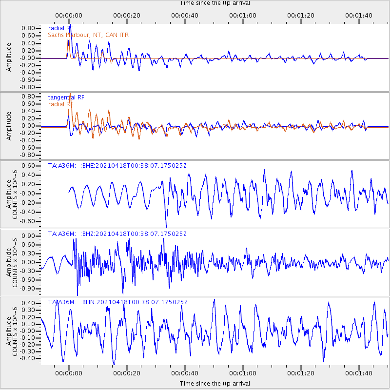
A36M Sachs Harbour, NT, CAN - Earthquake Result Viewer
*The percent match for this event was below the threshold and hence no stack was calculated.
| Earthquake location: |
Near East Coast Of Honshu, Japan |
| Earthquake latitude/longitude: |
38.4/141.9 |
| Earthquake time(UTC): |
2021/04/18 (108) 00:29:12 GMT |
| Earthquake Depth: |
52 km |
| Earthquake Magnitude: |
5.6 mww |
| Earthquake Catalog/Contributor: |
NEIC PDE/us |
|
| Network: |
TA USArray Transportable Network (new EarthScope stations) |
| Station: |
A36M Sachs Harbour, NT, CAN |
| Lat/Lon: |
71.99 N/125.25 W |
| Elevation: |
32 m |
|
| Distance: |
54.9 deg |
| Az: |
22.325 deg |
| Baz: |
286.284 deg |
| Ray Param: |
$rayparam |
*The percent match for this event was below the threshold and hence was not used in the summary stack. |
|
| Radial Match: |
74.55379 % |
| Radial Bump: |
400 |
| Transverse Match: |
52.47961 % |
| Transverse Bump: |
400 |
| SOD ConfigId: |
24334971 |
| Insert Time: |
2021-05-02 00:51:19.330 +0000 |
| GWidth: |
2.5 |
| Max Bumps: |
400 |
| Tol: |
0.001 |
|
Signal To Noise
| Channel | StoN | STA | LTA |
| TA:A36M: :BHZ:20210418T00:38:07.175025Z | 2.8017242 | 4.0677926E-7 | 1.4518889E-7 |
| TA:A36M: :BHN:20210418T00:38:07.175025Z | 0.88845897 | 1.9267678E-7 | 2.1686627E-7 |
| TA:A36M: :BHE:20210418T00:38:07.175025Z | 1.6263196 | 2.656737E-7 | 1.6335883E-7 |
| Arrivals |
| Ps | |
| PpPs | |
| PsPs/PpSs | |


