You are here: Home > Network List > TA - USArray Transportable Network (new EarthScope stations) Stations List
> Station C24K Franklin Bluffs, AK, USA > Earthquake Result Viewer
C24K Franklin Bluffs, AK, USA - Earthquake Result Viewer
| Earthquake location: |
Near East Coast Of Honshu, Japan |
| Earthquake latitude/longitude: |
38.4/141.9 |
| Earthquake time(UTC): |
2021/04/18 (108) 00:29:12 GMT |
| Earthquake Depth: |
52 km |
| Earthquake Magnitude: |
5.6 mww |
| Earthquake Catalog/Contributor: |
NEIC PDE/us |
|
| Network: |
TA USArray Transportable Network (new EarthScope stations) |
| Station: |
C24K Franklin Bluffs, AK, USA |
| Lat/Lon: |
69.72 N/148.70 W |
| Elevation: |
115 m |
|
| Distance: |
47.5 deg |
| Az: |
26.277 deg |
| Baz: |
266.588 deg |
| Ray Param: |
0.069837555 |
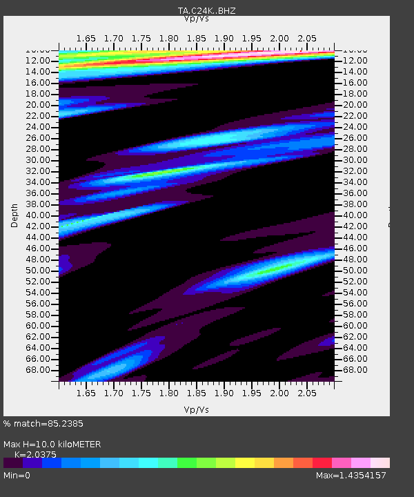
| Estimated Moho Depth: |
10.0 km |
| Estimated Crust Vp/Vs: |
2.04 |
| Assumed Crust Vp: |
6.316 km/s |
| Estimated Crust Vs: |
3.1 km/s |
| Estimated Crust Poisson's Ratio: |
0.34 |
|
| Radial Match: |
85.2385 % |
| Radial Bump: |
400 |
| Transverse Match: |
76.58211 % |
| Transverse Bump: |
400 |
| SOD ConfigId: |
24334971 |
| Insert Time: |
2021-05-02 00:51:19.555 +0000 |
| GWidth: |
2.5 |
| Max Bumps: |
400 |
| Tol: |
0.001 |
|

Signal To Noise
| Channel | StoN | STA | LTA |
| TA:C24K: :BHZ:20210418T00:37:11.850013Z | 6.042186 | 8.467411E-7 | 1.4013821E-7 |
| TA:C24K: :BHN:20210418T00:37:11.850013Z | 1.1161479 | 1.4860134E-7 | 1.3313768E-7 |
| TA:C24K: :BHE:20210418T00:37:11.850013Z | 3.2536662 | 3.7833794E-7 | 1.1628051E-7 |
| Arrivals |
| Ps | 1.7 SECOND |
| PpPs | 4.6 SECOND |
| PsPs/PpSs | 6.3 SECOND |


