You are here: Home > Network List > TA - USArray Transportable Network (new EarthScope stations) Stations List
> Station H31M Peel River, Yukon, CAN > Earthquake Result Viewer
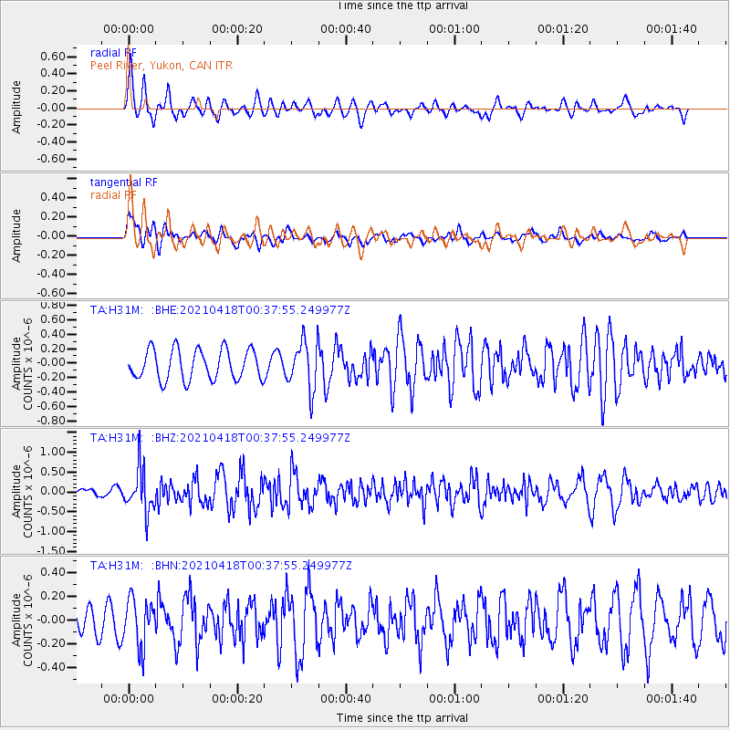
H31M Peel River, Yukon, CAN - Earthquake Result Viewer
*The percent match for this event was below the threshold and hence no stack was calculated.
| Earthquake location: |
Near East Coast Of Honshu, Japan |
| Earthquake latitude/longitude: |
38.4/141.9 |
| Earthquake time(UTC): |
2021/04/18 (108) 00:29:12 GMT |
| Earthquake Depth: |
52 km |
| Earthquake Magnitude: |
5.6 mww |
| Earthquake Catalog/Contributor: |
NEIC PDE/us |
|
| Network: |
TA USArray Transportable Network (new EarthScope stations) |
| Station: |
H31M Peel River, Yukon, CAN |
| Lat/Lon: |
65.81 N/134.34 W |
| Elevation: |
642 m |
|
| Distance: |
53.2 deg |
| Az: |
30.752 deg |
| Baz: |
282.742 deg |
| Ray Param: |
$rayparam |
*The percent match for this event was below the threshold and hence was not used in the summary stack. |
|
| Radial Match: |
62.65625 % |
| Radial Bump: |
400 |
| Transverse Match: |
61.497116 % |
| Transverse Bump: |
400 |
| SOD ConfigId: |
24334971 |
| Insert Time: |
2021-05-02 00:52:04.359 +0000 |
| GWidth: |
2.5 |
| Max Bumps: |
400 |
| Tol: |
0.001 |
|
Signal To Noise
| Channel | StoN | STA | LTA |
| TA:H31M: :BHZ:20210418T00:37:55.249977Z | 3.6071792 | 5.443211E-7 | 1.5089937E-7 |
| TA:H31M: :BHN:20210418T00:37:55.249977Z | 1.8661644 | 1.9857254E-7 | 1.06406766E-7 |
| TA:H31M: :BHE:20210418T00:37:55.249977Z | 1.6087687 | 3.3542665E-7 | 2.0849899E-7 |
| Arrivals |
| Ps | |
| PpPs | |
| PsPs/PpSs | |


