You are here: Home > Network List > TA - USArray Transportable Network (new EarthScope stations) Stations List
> Station I17K Unalakleet, AK, USA > Earthquake Result Viewer
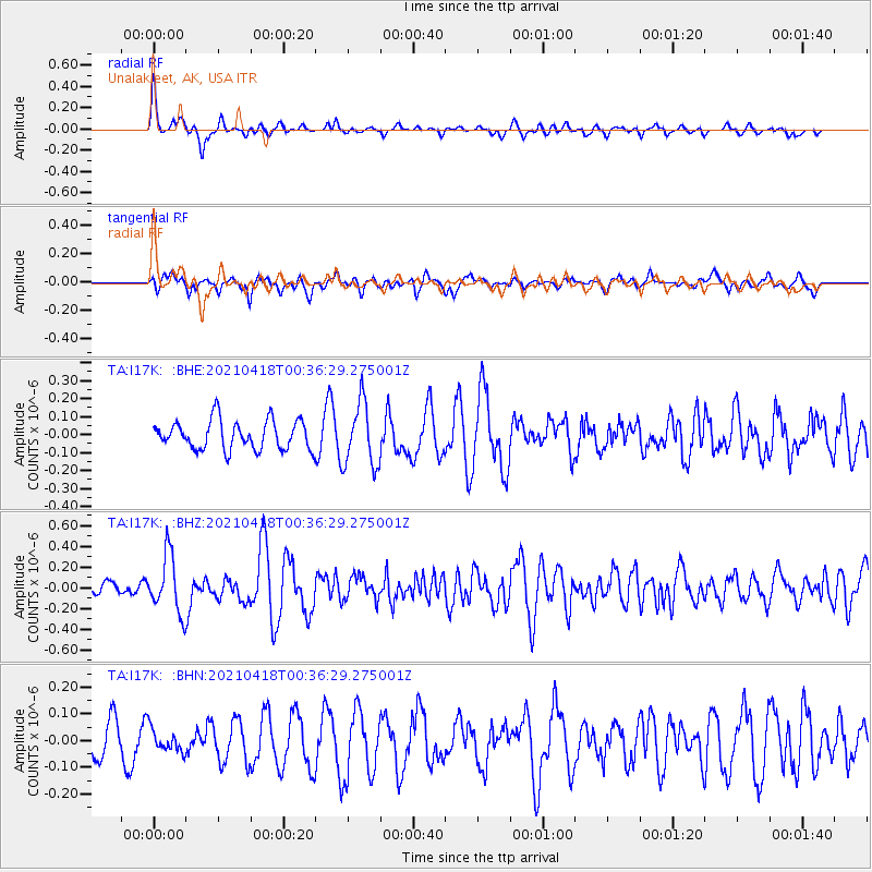
I17K Unalakleet, AK, USA - Earthquake Result Viewer
*The percent match for this event was below the threshold and hence no stack was calculated.
| Earthquake location: |
Near East Coast Of Honshu, Japan |
| Earthquake latitude/longitude: |
38.4/141.9 |
| Earthquake time(UTC): |
2021/04/18 (108) 00:29:12 GMT |
| Earthquake Depth: |
52 km |
| Earthquake Magnitude: |
5.6 mww |
| Earthquake Catalog/Contributor: |
NEIC PDE/us |
|
| Network: |
TA USArray Transportable Network (new EarthScope stations) |
| Station: |
I17K Unalakleet, AK, USA |
| Lat/Lon: |
63.89 N/160.70 W |
| Elevation: |
105 m |
|
| Distance: |
42.1 deg |
| Az: |
33.765 deg |
| Baz: |
260.877 deg |
| Ray Param: |
$rayparam |
*The percent match for this event was below the threshold and hence was not used in the summary stack. |
|
| Radial Match: |
69.585335 % |
| Radial Bump: |
367 |
| Transverse Match: |
68.74913 % |
| Transverse Bump: |
400 |
| SOD ConfigId: |
24334971 |
| Insert Time: |
2021-05-02 00:52:06.183 +0000 |
| GWidth: |
2.5 |
| Max Bumps: |
400 |
| Tol: |
0.001 |
|
Signal To Noise
| Channel | StoN | STA | LTA |
| TA:I17K: :BHZ:20210418T00:36:29.275001Z | 2.724309 | 2.7906682E-7 | 1.0243582E-7 |
| TA:I17K: :BHN:20210418T00:36:29.275001Z | 0.55431056 | 4.301117E-8 | 7.759399E-8 |
| TA:I17K: :BHE:20210418T00:36:29.275001Z | 2.2073996 | 1.7695668E-7 | 8.016522E-8 |
| Arrivals |
| Ps | |
| PpPs | |
| PsPs/PpSs | |


