You are here: Home > Network List > NO - Norwegian Seismic Array Network Stations List
> Station SPB1 > Earthquake Result Viewer
SPB1 - Earthquake Result Viewer
| Earthquake location: |
Iran-Iraq Border Region |
| Earthquake latitude/longitude: |
34.9/46.0 |
| Earthquake time(UTC): |
2017/11/12 (316) 18:18:17 GMT |
| Earthquake Depth: |
19 km |
| Earthquake Magnitude: |
7.3 Mww |
| Earthquake Catalog/Contributor: |
NEIC PDE/us |
|
| Network: |
NO Norwegian Seismic Array Network |
| Station: |
SPB1 |
| Lat/Lon: |
78.18 N/16.39 E |
| Elevation: |
301 m |
|
| Distance: |
45.2 deg |
| Az: |
351.756 deg |
| Baz: |
145.135 deg |
| Ray Param: |
0.071418695 |
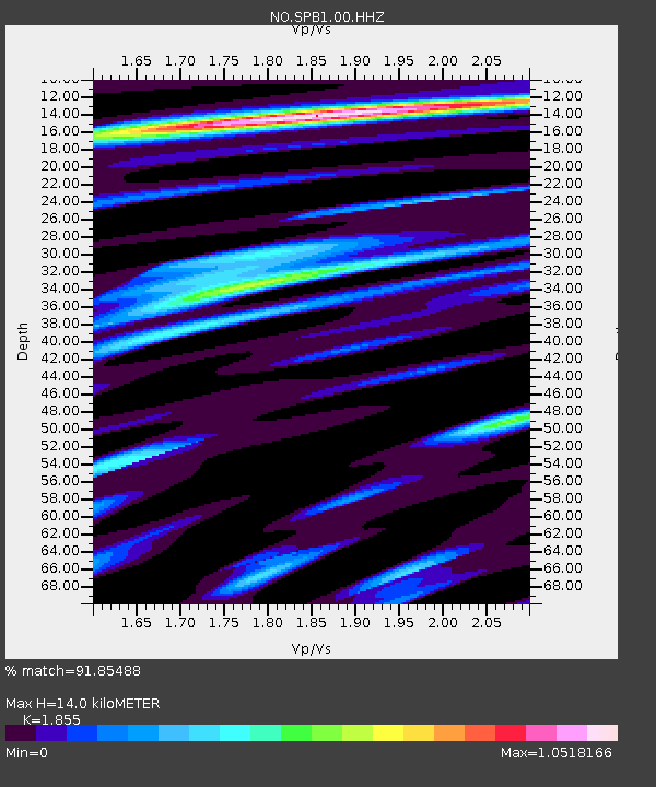
| Estimated Moho Depth: |
14.0 km |
| Estimated Crust Vp/Vs: |
1.86 |
| Assumed Crust Vp: |
6.545 km/s |
| Estimated Crust Vs: |
3.528 km/s |
| Estimated Crust Poisson's Ratio: |
0.30 |
|
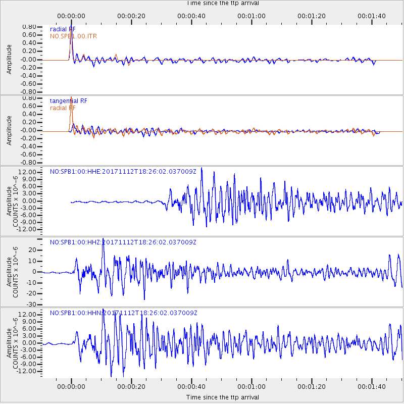
| Radial Match: |
91.85488 % |
| Radial Bump: |
366 |
| Transverse Match: |
81.13565 % |
| Transverse Bump: |
400 |
| SOD ConfigId: |
2429771 |
| Insert Time: |
2017-11-26 18:21:41.603 +0000 |
| GWidth: |
2.5 |
| Max Bumps: |
400 |
| Tol: |
0.001 |
|
Signal To Noise
| Channel | StoN | STA | LTA |
| NO:SPB1:00:HHZ:20171112T18:26:02.037009Z | 23.844294 | 6.0815305E-6 | 2.5505182E-7 |
| NO:SPB1:00:HHN:20171112T18:26:02.037009Z | 13.385961 | 2.7563729E-6 | 2.059152E-7 |
| NO:SPB1:00:HHE:20171112T18:26:02.037009Z | 10.001808 | 1.9460367E-6 | 1.945685E-7 |
| Arrivals |
| Ps | 1.9 SECOND |
| PpPs | 5.7 SECOND |
| PsPs/PpSs | 7.7 SECOND |


