You are here: Home > Network List > PF - Volcanologic Network of Piton de Fournaise-OVPF Stations List
> Station CAM College de Cambuston > Earthquake Result Viewer
CAM College de Cambuston - Earthquake Result Viewer
| Earthquake location: |
Iran-Iraq Border Region |
| Earthquake latitude/longitude: |
34.9/46.0 |
| Earthquake time(UTC): |
2017/11/12 (316) 18:18:17 GMT |
| Earthquake Depth: |
19 km |
| Earthquake Magnitude: |
7.3 Mww |
| Earthquake Catalog/Contributor: |
NEIC PDE/us |
|
| Network: |
PF Volcanologic Network of Piton de Fournaise-OVPF |
| Station: |
CAM College de Cambuston |
| Lat/Lon: |
20.93 S/55.65 E |
| Elevation: |
15 m |
|
| Distance: |
56.3 deg |
| Az: |
169.095 deg |
| Baz: |
350.426 deg |
| Ray Param: |
0.06422063 |
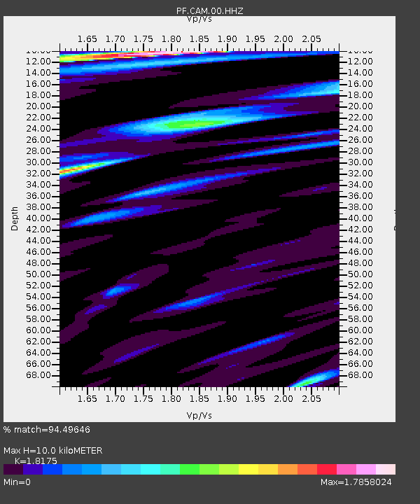
| Estimated Moho Depth: |
10.0 km |
| Estimated Crust Vp/Vs: |
1.82 |
| Assumed Crust Vp: |
4.73 km/s |
| Estimated Crust Vs: |
2.602 km/s |
| Estimated Crust Poisson's Ratio: |
0.28 |
|
| Radial Match: |
94.49646 % |
| Radial Bump: |
400 |
| Transverse Match: |
84.50624 % |
| Transverse Bump: |
400 |
| SOD ConfigId: |
2429771 |
| Insert Time: |
2017-11-26 18:21:52.376 +0000 |
| GWidth: |
2.5 |
| Max Bumps: |
400 |
| Tol: |
0.001 |
|
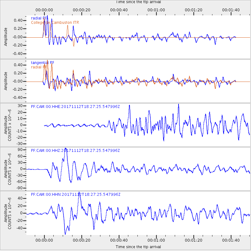
Signal To Noise
| Channel | StoN | STA | LTA |
| PF:CAM:00:HHZ:20171112T18:27:25.547996Z | 16.273033 | 1.8296087E-5 | 1.1243193E-6 |
| PF:CAM:00:HHN:20171112T18:27:25.547996Z | 8.579134 | 8.117009E-6 | 9.461338E-7 |
| PF:CAM:00:HHE:20171112T18:27:25.547996Z | 2.2854767 | 2.410914E-6 | 1.0548846E-6 |
| Arrivals |
| Ps | 1.8 SECOND |
| PpPs | 5.8 SECOND |
| PsPs/PpSs | 7.6 SECOND |


