You are here: Home > Network List > PF - Volcanologic Network of Piton de Fournaise-OVPF Stations List
> Station FLR Station Sismologique de Flanc Est > Earthquake Result Viewer
FLR Station Sismologique de Flanc Est - Earthquake Result Viewer
| Earthquake location: |
Iran-Iraq Border Region |
| Earthquake latitude/longitude: |
34.9/46.0 |
| Earthquake time(UTC): |
2017/11/12 (316) 18:18:17 GMT |
| Earthquake Depth: |
19 km |
| Earthquake Magnitude: |
7.3 Mww |
| Earthquake Catalog/Contributor: |
NEIC PDE/us |
|
| Network: |
PF Volcanologic Network of Piton de Fournaise-OVPF |
| Station: |
FLR Station Sismologique de Flanc Est |
| Lat/Lon: |
21.24 S/55.73 E |
| Elevation: |
1947 m |
|
| Distance: |
56.6 deg |
| Az: |
169.062 deg |
| Baz: |
350.377 deg |
| Ray Param: |
0.06401261 |
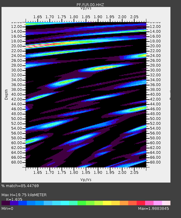
| Estimated Moho Depth: |
19.75 km |
| Estimated Crust Vp/Vs: |
1.63 |
| Assumed Crust Vp: |
4.73 km/s |
| Estimated Crust Vs: |
2.893 km/s |
| Estimated Crust Poisson's Ratio: |
0.20 |
|
| Radial Match: |
85.44769 % |
| Radial Bump: |
400 |
| Transverse Match: |
80.099106 % |
| Transverse Bump: |
400 |
| SOD ConfigId: |
2429771 |
| Insert Time: |
2017-11-26 18:21:59.897 +0000 |
| GWidth: |
2.5 |
| Max Bumps: |
400 |
| Tol: |
0.001 |
|
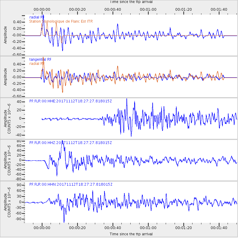
Signal To Noise
| Channel | StoN | STA | LTA |
| PF:FLR:00:HHZ:20171112T18:27:27.818015Z | 18.705559 | 1.612564E-5 | 8.620774E-7 |
| PF:FLR:00:HHN:20171112T18:27:27.818015Z | 6.918768 | 9.127352E-6 | 1.3192165E-6 |
| PF:FLR:00:HHE:20171112T18:27:27.818015Z | 1.4118901 | 1.839108E-6 | 1.3025857E-6 |
| Arrivals |
| Ps | 2.7 SECOND |
| PpPs | 11 SECOND |
| PsPs/PpSs | 13 SECOND |


