You are here: Home > Network List > PF - Volcanologic Network of Piton de Fournaise-OVPF Stations List
> Station FOR Station Sismologique de Chateau Fort > Earthquake Result Viewer
FOR Station Sismologique de Chateau Fort - Earthquake Result Viewer
| Earthquake location: |
Iran-Iraq Border Region |
| Earthquake latitude/longitude: |
34.9/46.0 |
| Earthquake time(UTC): |
2017/11/12 (316) 18:18:17 GMT |
| Earthquake Depth: |
19 km |
| Earthquake Magnitude: |
7.3 Mww |
| Earthquake Catalog/Contributor: |
NEIC PDE/us |
|
| Network: |
PF Volcanologic Network of Piton de Fournaise-OVPF |
| Station: |
FOR Station Sismologique de Chateau Fort |
| Lat/Lon: |
21.26 S/55.72 E |
| Elevation: |
2049 m |
|
| Distance: |
56.6 deg |
| Az: |
169.082 deg |
| Baz: |
350.393 deg |
| Ray Param: |
0.06400045 |
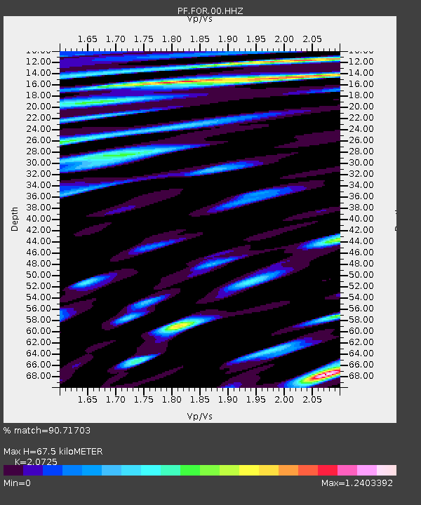
| Estimated Moho Depth: |
67.5 km |
| Estimated Crust Vp/Vs: |
2.07 |
| Assumed Crust Vp: |
4.73 km/s |
| Estimated Crust Vs: |
2.282 km/s |
| Estimated Crust Poisson's Ratio: |
0.35 |
|
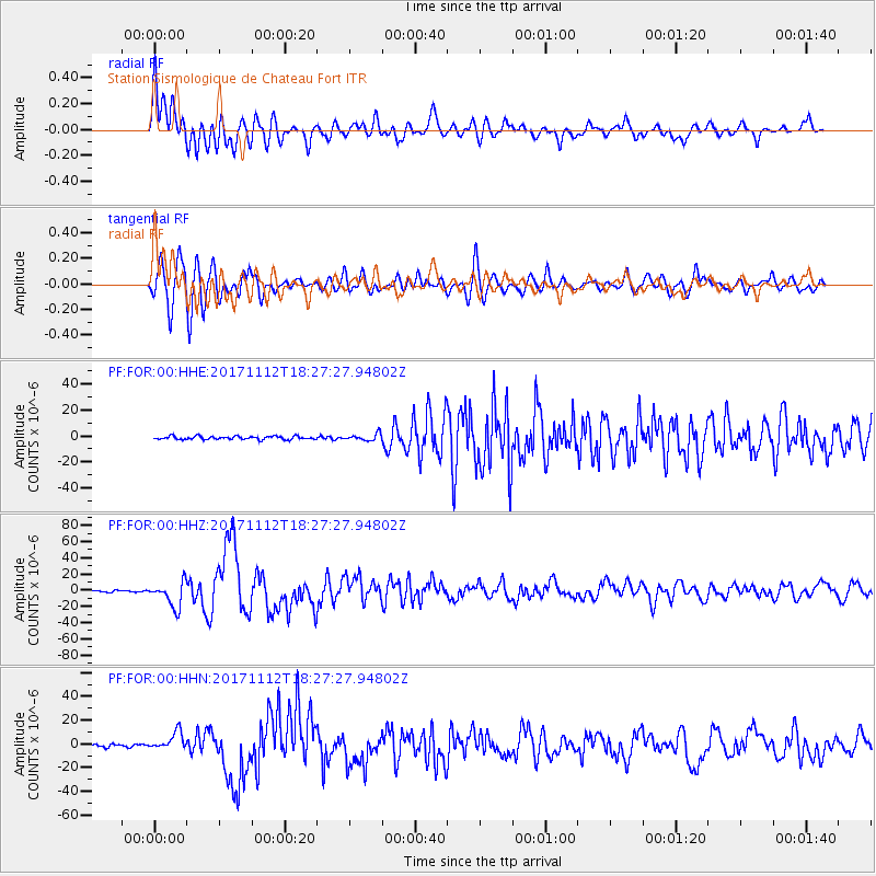
| Radial Match: |
90.71703 % |
| Radial Bump: |
400 |
| Transverse Match: |
81.67135 % |
| Transverse Bump: |
400 |
| SOD ConfigId: |
2429771 |
| Insert Time: |
2017-11-26 18:22:01.421 +0000 |
| GWidth: |
2.5 |
| Max Bumps: |
400 |
| Tol: |
0.001 |
|
Signal To Noise
| Channel | StoN | STA | LTA |
| PF:FOR:00:HHZ:20171112T18:27:27.94802Z | 16.527739 | 1.5583613E-5 | 9.428764E-7 |
| PF:FOR:00:HHN:20171112T18:27:27.94802Z | 7.816715 | 7.5832822E-6 | 9.701367E-7 |
| PF:FOR:00:HHE:20171112T18:27:27.94802Z | 2.0397143 | 2.645136E-6 | 1.2968168E-6 |
| Arrivals |
| Ps | 16 SECOND |
| PpPs | 43 SECOND |
| PsPs/PpSs | 59 SECOND |


