You are here: Home > Network List > PF - Volcanologic Network of Piton de Fournaise-OVPF Stations List
> Station FRE Station Sismologique des Fonds de la Riviere de l'Est > Earthquake Result Viewer
FRE Station Sismologique des Fonds de la Riviere de l'Est - Earthquake Result Viewer
| Earthquake location: |
Iran-Iraq Border Region |
| Earthquake latitude/longitude: |
34.9/46.0 |
| Earthquake time(UTC): |
2017/11/12 (316) 18:18:17 GMT |
| Earthquake Depth: |
19 km |
| Earthquake Magnitude: |
7.3 Mww |
| Earthquake Catalog/Contributor: |
NEIC PDE/us |
|
| Network: |
PF Volcanologic Network of Piton de Fournaise-OVPF |
| Station: |
FRE Station Sismologique des Fonds de la Riviere de l'Est |
| Lat/Lon: |
21.20 S/55.70 E |
| Elevation: |
1775 m |
|
| Distance: |
56.6 deg |
| Az: |
169.096 deg |
| Baz: |
350.409 deg |
| Ray Param: |
0.064041525 |
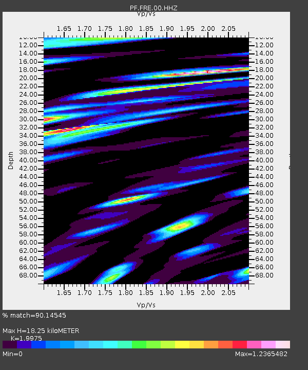
| Estimated Moho Depth: |
18.25 km |
| Estimated Crust Vp/Vs: |
2.00 |
| Assumed Crust Vp: |
4.73 km/s |
| Estimated Crust Vs: |
2.368 km/s |
| Estimated Crust Poisson's Ratio: |
0.33 |
|
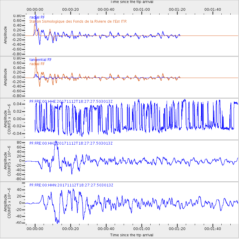
| Radial Match: |
90.14545 % |
| Radial Bump: |
400 |
| Transverse Match: |
90.12979 % |
| Transverse Bump: |
400 |
| SOD ConfigId: |
2429771 |
| Insert Time: |
2017-11-26 18:22:03.181 +0000 |
| GWidth: |
2.5 |
| Max Bumps: |
400 |
| Tol: |
0.001 |
|
Signal To Noise
| Channel | StoN | STA | LTA |
| PF:FRE:00:HHZ:20171112T18:27:27.503013Z | 13.215201 | 1.39439E-5 | 1.055141E-6 |
| PF:FRE:00:HHN:20171112T18:27:27.503013Z | 11.772159 | 9.761698E-6 | 8.29219E-7 |
| PF:FRE:00:HHE:20171112T18:27:27.503013Z | 1.0096959 | 3.1650078E-8 | 3.1346147E-8 |
| Arrivals |
| Ps | 3.9 SECOND |
| PpPs | 11 SECOND |
| PsPs/PpSs | 15 SECOND |


