You are here: Home > Network List > PF - Volcanologic Network of Piton de Fournaise-OVPF Stations List
> Station GBS Grandes pentes coulee 1943 bas > Earthquake Result Viewer
GBS Grandes pentes coulee 1943 bas - Earthquake Result Viewer
| Earthquake location: |
Iran-Iraq Border Region |
| Earthquake latitude/longitude: |
34.9/46.0 |
| Earthquake time(UTC): |
2017/11/12 (316) 18:18:17 GMT |
| Earthquake Depth: |
19 km |
| Earthquake Magnitude: |
7.3 Mww |
| Earthquake Catalog/Contributor: |
NEIC PDE/us |
|
| Network: |
PF Volcanologic Network of Piton de Fournaise-OVPF |
| Station: |
GBS Grandes pentes coulee 1943 bas |
| Lat/Lon: |
21.27 S/55.78 E |
| Elevation: |
471 m |
|
| Distance: |
56.6 deg |
| Az: |
169.018 deg |
| Baz: |
350.336 deg |
| Ray Param: |
0.06398649 |
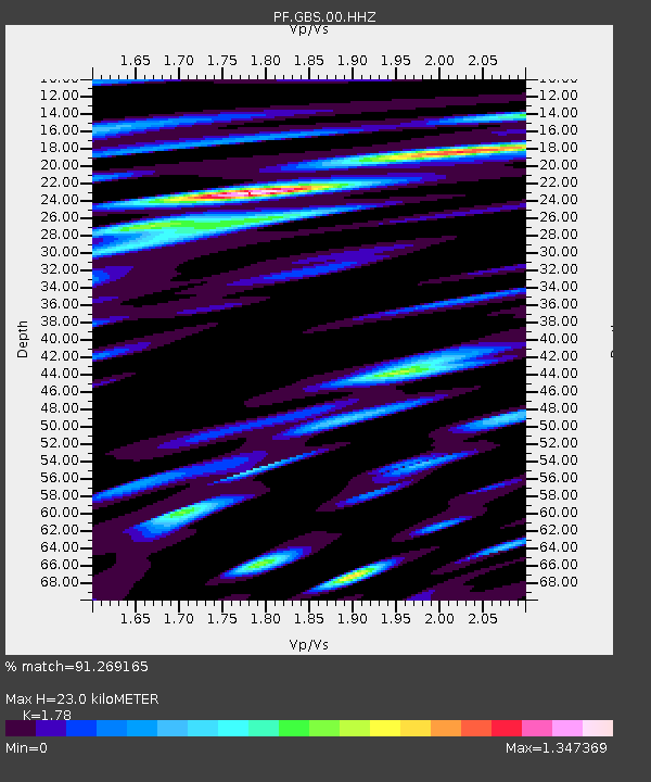
| Estimated Moho Depth: |
23.0 km |
| Estimated Crust Vp/Vs: |
1.78 |
| Assumed Crust Vp: |
4.73 km/s |
| Estimated Crust Vs: |
2.657 km/s |
| Estimated Crust Poisson's Ratio: |
0.27 |
|
| Radial Match: |
91.269165 % |
| Radial Bump: |
400 |
| Transverse Match: |
80.079704 % |
| Transverse Bump: |
400 |
| SOD ConfigId: |
2429771 |
| Insert Time: |
2017-11-26 18:22:05.195 +0000 |
| GWidth: |
2.5 |
| Max Bumps: |
400 |
| Tol: |
0.001 |
|
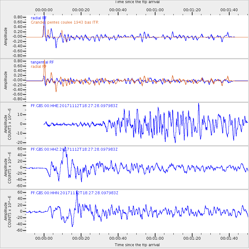
Signal To Noise
| Channel | StoN | STA | LTA |
| PF:GBS:00:HHZ:20171112T18:27:28.097983Z | 15.522752 | 1.32539435E-5 | 8.538398E-7 |
| PF:GBS:00:HHN:20171112T18:27:28.097983Z | 8.068803 | 9.5910145E-6 | 1.188654E-6 |
| PF:GBS:00:HHE:20171112T18:27:28.097983Z | 2.9516735 | 2.8196973E-6 | 9.552878E-7 |
| Arrivals |
| Ps | 3.9 SECOND |
| PpPs | 13 SECOND |
| PsPs/PpSs | 17 SECOND |


