You are here: Home > Network List > PF - Volcanologic Network of Piton de Fournaise-OVPF Stations List
> Station GPN Grandes Pentes Nord > Earthquake Result Viewer
GPN Grandes Pentes Nord - Earthquake Result Viewer
| Earthquake location: |
Iran-Iraq Border Region |
| Earthquake latitude/longitude: |
34.9/46.0 |
| Earthquake time(UTC): |
2017/11/12 (316) 18:18:17 GMT |
| Earthquake Depth: |
19 km |
| Earthquake Magnitude: |
7.3 Mww |
| Earthquake Catalog/Contributor: |
NEIC PDE/us |
|
| Network: |
PF Volcanologic Network of Piton de Fournaise-OVPF |
| Station: |
GPN Grandes Pentes Nord |
| Lat/Lon: |
21.24 S/55.75 E |
| Elevation: |
1413 m |
|
| Distance: |
56.6 deg |
| Az: |
169.041 deg |
| Baz: |
350.358 deg |
| Ray Param: |
0.064011216 |
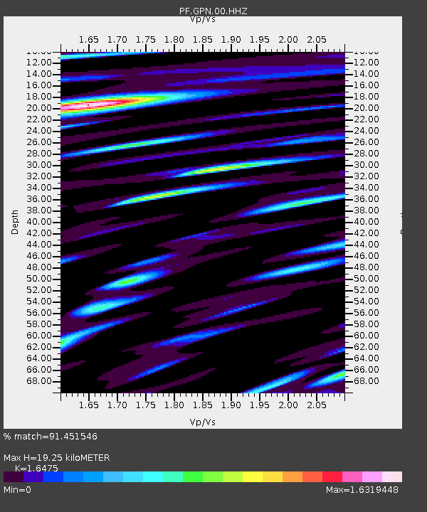
| Estimated Moho Depth: |
19.25 km |
| Estimated Crust Vp/Vs: |
1.65 |
| Assumed Crust Vp: |
4.73 km/s |
| Estimated Crust Vs: |
2.871 km/s |
| Estimated Crust Poisson's Ratio: |
0.21 |
|
| Radial Match: |
91.451546 % |
| Radial Bump: |
400 |
| Transverse Match: |
86.66266 % |
| Transverse Bump: |
400 |
| SOD ConfigId: |
2429771 |
| Insert Time: |
2017-11-26 18:22:06.802 +0000 |
| GWidth: |
2.5 |
| Max Bumps: |
400 |
| Tol: |
0.001 |
|
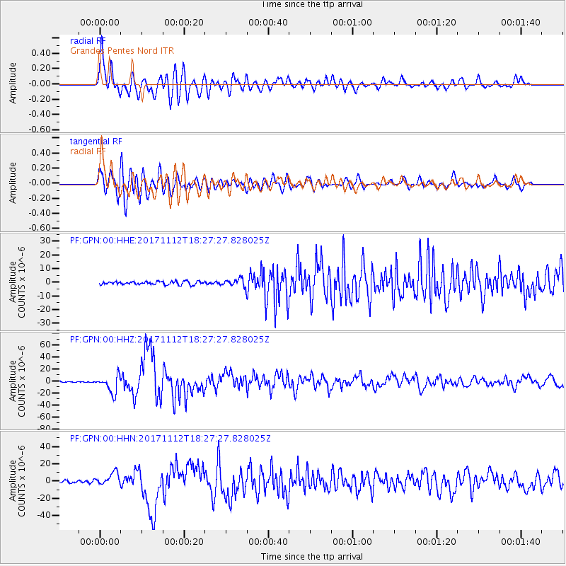
Signal To Noise
| Channel | StoN | STA | LTA |
| PF:GPN:00:HHZ:20171112T18:27:27.828025Z | 16.013802 | 1.4771355E-5 | 9.224141E-7 |
| PF:GPN:00:HHN:20171112T18:27:27.828025Z | 6.6730685 | 7.5874013E-6 | 1.1370183E-6 |
| PF:GPN:00:HHE:20171112T18:27:27.828025Z | 2.4788444 | 2.8089491E-6 | 1.1331688E-6 |
| Arrivals |
| Ps | 2.7 SECOND |
| PpPs | 10 SECOND |
| PsPs/PpSs | 13 SECOND |


