You are here: Home > Network List > AK - Alaska Regional Network Stations List
> Station D20K Etivluk River, AK, USA > Earthquake Result Viewer
D20K Etivluk River, AK, USA - Earthquake Result Viewer
| Earthquake location: |
Near East Coast Of Honshu, Japan |
| Earthquake latitude/longitude: |
38.3/141.8 |
| Earthquake time(UTC): |
2021/04/18 (108) 00:29:25 GMT |
| Earthquake Depth: |
31 km |
| Earthquake Magnitude: |
5.6 mb |
| Earthquake Catalog/Contributor: |
NEIC PDE/us |
|
| Network: |
AK Alaska Regional Network |
| Station: |
D20K Etivluk River, AK, USA |
| Lat/Lon: |
68.71 N/156.61 W |
| Elevation: |
577 m |
|
| Distance: |
44.7 deg |
| Az: |
27.172 deg |
| Baz: |
259.856 deg |
| Ray Param: |
0.071720056 |
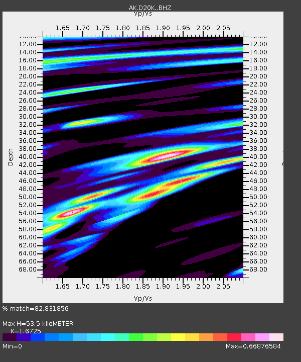
| Estimated Moho Depth: |
53.5 km |
| Estimated Crust Vp/Vs: |
1.67 |
| Assumed Crust Vp: |
6.221 km/s |
| Estimated Crust Vs: |
3.72 km/s |
| Estimated Crust Poisson's Ratio: |
0.22 |
|
| Radial Match: |
82.831856 % |
| Radial Bump: |
400 |
| Transverse Match: |
76.18454 % |
| Transverse Bump: |
400 |
| SOD ConfigId: |
24334971 |
| Insert Time: |
2021-05-02 01:00:43.073 +0000 |
| GWidth: |
2.5 |
| Max Bumps: |
400 |
| Tol: |
0.001 |
|

Signal To Noise
| Channel | StoN | STA | LTA |
| AK:D20K: :BHZ:20210418T00:37:04.320013Z | 2.0701494 | 7.6603004E-7 | 3.700361E-7 |
| AK:D20K: :BHN:20210418T00:37:04.320013Z | 1.9779868 | 1.9548878E-7 | 9.8832196E-8 |
| AK:D20K: :BHE:20210418T00:37:04.320013Z | 2.0639863 | 3.4542853E-7 | 1.673599E-7 |
| Arrivals |
| Ps | 6.2 SECOND |
| PpPs | 22 SECOND |
| PsPs/PpSs | 28 SECOND |


